ST. GEORGE — A strong thunderstorm that knocked out power in Mesquite, Nevada, at approximately 8 p.m. and moved through the St. George area is continuing to wreak havoc as it moves northeast along the Interstate 15 corridor.
At 10:02 p.m., the National Weather Service issued a severe thunderstorm warning for Washington and Iron counties through 11 p.m. as Doppler radar was tracking a cluster of strong thunderstorms 8 miles east of New Harmony, or 12 miles south of Cedar City, moving northeast at 35 mph.
Wind gusts up to 50 mph and pea-sized hail are anticipated.
Areas expected to be impacted include Cedar City, Zion National Park, Enoch, Parowan, New Harmony, Cedar Breaks National Monument, Summit, Kanarraville, Brian Head, Hamilton Fort and Kolob Canyon. This also includes the
I-15 between mile markers 34 and 77 and state Route 56 between mile markers 47 and 61.
Earlier in the evening, the NWS issued a Special Weather Statement for the following areas: St George, Washington, Hurricane, Santa Clara, La Verkin, Dameron Valley, Quail Creek State Park, Sand Hollow State Park, Gunlock State Park, Ivins, Toquerville, Leeds, Virgin, Motoqua, Pintura, Bloomington, Gunlock, Veyo, Snow Canyon State Park and Goldstrike.

St. George News reporter Nick Yamashita was in Mesquite when the storm hit and said there was heavy rain, strong winds, thunder and lightning.
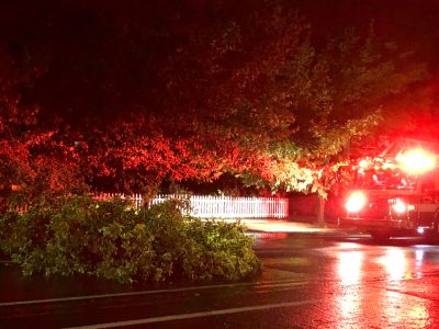
Eyewitness reports indicate at least one large tree down in St. George, a lightning strike of a power substation off Cotton Wood Springs Road and hail in LaVerkin. Additional reports include separate lightning strikes of a vehicle in Hurricane and a truck on I-15 near Exit 16.
The weather service said at 8:29 p.m., “Doppler radar was tracking a strong thunderstorm 8 miles southeast of Virgin River Campground, or 8 miles southeast of Virgin River Gorge, moving northeast at 25 mph … Wind gusts of 50 to 55 mph … Gusty winds could knock down tree limbs and blow around unsecured objects.
Interstate 15 between mile markers 1 and 33 and state Route 18 between mile markers 0 and 23 also are expected to be impacted.
The NWS also is cautioning residents of the impacted areas to “consider seeking shelter inside a building … Frequent cloud to ground lightning is occurring with this storm … Lightning can strike 10 miles away from a thunderstorm. Seek a safe … shelter inside a building or vehicle … Locally heavy rainfall is also possible with these storms and could lead to ponding of water on roadways. Reduce driving speeds.”

Updated 9:50 p.m., Aug. 31: The weather service has issued several additional advisories, including a flood advisory in effect until midnight for Washington County.
“Minor flooding in low-lying and poor drainage areas. Overflowing poor drainage areas. Ponding of water in urban or
other areas is occurring or is imminent,” according to an NWS news release.
The storm cell is dropping heavy rain and hail across Southern Utah and is likely to or already has caused urban and small stream flooding. Overflowing poor drainage areas will cause minor flooding in the advisory area. Some locations that will experience flooding include St George, Washington, Hurricane, Santa Clara, Sand Hollow State Park, Quail Creek State Park, Ivins, Bloomington and Snow Canyon State Park.
Updated 10:09 p.m. Aug. 31: Story now includes weather alert for Iron County.
Video below by St. George News reporter Alysha Lundgren.