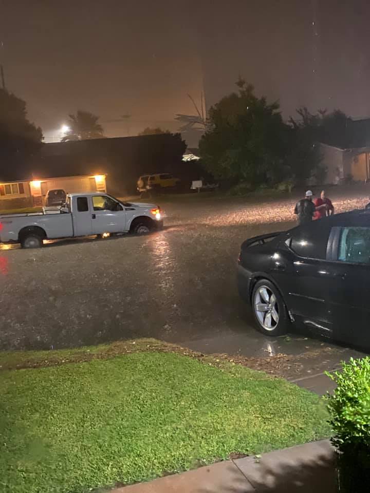
ST. GEORGE — Although there is still lingering evidence of the recent thunderstorm that pummeled St. George two weeks ago, city officials are not surprised by the amount of flooding that occurred in certain portions of town.
According to the National Oceanic and Atmospheric Administration, much of St. George experienced a deluge of 2 inches of rain between 8:30-10:30 p.m. on Aug. 23, with the remnants of the storm finally moving south away from Washington County by around at midnight.
In the storm’s wake, some residents were left without power from fried electrical panels, kitchen appliances and computers that were forever rendered inoperable, family pets who would not come out from hiding under the bed for days, and standing water in nearly every room of their home.
“I watched as the storm rolled in,” resident Karen Johnson said. “It started to sprinkle, and within a minute it poured, then thunder and then the water started coming up from the floor. I didn’t know what to do. I couldn’t leave. I was scared to stay, but what choice did I have.”
More than two weeks after the storm, cleanup crews were still removing carpet and replacing drywall and baseboards from flooding that seeped up from the concrete subfloor.
“It’s been a mess,” Johnson said. “I’ve lived in my apartment for a few years, and I’ve never seen anything like that.”

Cameron Cutler, director of public works for the city of St. George, said the high-intensity storm did cause damage, but it could have been worse.
“When it comes to the Federal Emergency Management Agency, they regulate where floodplains are designated and a lot of residents don’t fully understand this but usually these are areas that flood frequently,” Cutler said.
In 2015, FEMA began a multiyear update of floodplain maps across the county to analyze community or regional risk factors.
The risk analysis includes evaluating and modeling flood hazards that could affect city infrastructure, flood control structures located on state land, and modeling of flood events and how they are conveyed through a city via drainage channels or culverts.
Modeling data also assessed river channel stability — such as potential lateral erosion, scour, long-term aggradation and degradation.
The analysis also includes an assessment of flood protection levels associated with levee-like structures located within and outside city limits based on updated hydrologic and hydraulic analyses and development of nonregulatory risk map products to help communicate to the public the hazards and risks associated with high-risk areas.
Flood hazard mapping is an important part of the National Flood Insurance Program, as it is the basis of the NFIP regulations and flood insurance requirements. FEMA uses Flood Insurance Rate Maps to help determine flood insurance costs. The closer to a designated risk area the higher the cost for insurance, and depending on the severity of risk homeowners and businesses may not qualify for this assistance.
Although there is some protection from the federal flood insurance program most insurance companies do not cover “acts of God,” such as floods. While some private insurance companies offer compensation from floods based on the amount of risk in the floodplain, actuarial experts contacted by St. George News said it’s best to update or reevaluate home insurance policies annually.
Along with a change in flood risks other factors that warrant a refresh to homeowners insurance include renovations, communal improvements to the neighborhood and fluctuations in the market value of comparable homes.
A good example of how changes in floodplains change over time is along Flood Street.
In the past, homes along 400 East would flood during significant rain events, and when the city installed a storm drain, although it pulled the area out of a designated floodplain, it still had the potential of experiencing a 100-year flood event.
During the most recent storm, some rain gauges recorded a 1,000-year intensity rainfall with the average placed at 25-years and 500-years.
Other factors that contribute to citywide flooding include Interstate 15 that bisects St. George, which creates a damming effect in some portions of the city, and older building construction — exacerbated by the then city regulations — that did not properly drain infrastructures such as retaining walls, Cutler said.
“The interesting thing that during this storm and after the storm, the rivers were not running full,” he said. “Although it was a high-intensity storm, it wasn’t a long duration event or one that (encompassed) a huge area, and when I say a huge area, I mean half of the county that could have created (river related) floodwaters.”
It wasn’t the Virgin or Santa Clara rivers, including the Fort Pearce Wash and larger storm drains, that created the flooding problems, it was the smaller inlet pipes, roof drains and catch basins that were quickly overwhelmed, Cutler added.
According to the United States Geological Survey river flow data, on Aug. 23, the Virgin River peaked at 4,000 cubic feet per second with a 100-year storm estimated running at 23,500 CFS. Even a 10-year storm event between Washington City and the confluence of the Fort Pearce Wash measures 12,000 CFS.
“It was intense locally, but this puts the storm into perspective,” Cutler said.

From a design perspective, he added, the city’s infrastructure has the capacity to handle 10-year storm events with the caveat that the storm drains and culverts are not inundated by debris, which compromises their effectiveness.
One common misconception is that the flood damage on private property is the responsibility of the city to fix. Municipal regulations across the country say otherwise. Cities are responsible for streets, drainage and everything up to sidewalks, which are also the responsibility of property owners.
Sewer lines that connect homes and businesses to city mains are also the owner’s responsibility to fix.
“This is not to say we will not get into a business parking lot to try to help clean up, but this depends on the availability of our crews. Even as late as this week you can still see areas that the city is cleaning up,” Cutler said. “Most of the time after a storm owners will not wait but we will help out wherever we can.”
As a way to mitigate damage, city officials ask new residential and commercial developers to conduct drainage studies and engineer how rainwater can be diverted around structures.
For existing businesses and residential properties, Cutler said, an ounce of prevention is worth a pound of cure.
“Look around your property and where it has flooded in the past,” he added. “Determine ways to try to make things better. Hire an architect or engineer to do an analysis to figure out what is preventing the water from draining through and … if they qualify … consider flood insurance.”
Copyright St. George News, SaintGeorgeUtah.com LLC, 2020, all rights reserved.