ST. GEORGE — The National Weather Service has issued a winter storm warning for southwestern Utah starting Wednesday morning and running through Friday evening. There is also a winter weather advisory spanning the Interstate 15 corridor from south to north through Wednesday afternoon and a winter storm watch for the area through Saturday morning.
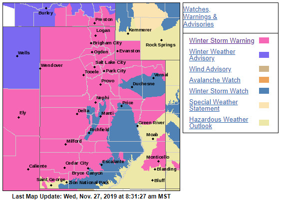
According to the NWS Salt Lake City office, heavy snow is being forecast as part of the winter storm watch for southwest Utah, southern mountains and south-central Utah.
The winter storm warning is predicting total snow accumulations of 10-20 inches possible in the valleys, with 1-3 feet possible in the mountains, with potential for locally higher amounts and wind gusts as high as 45 mph.
Specific local forecasts for St. George, Cedar City, Zion National Park and Brian Head follow below, along with winter travel safety and preparation tips.
St. George
Wednesday
A chance of snow before 11 a.m., then rain and snow likely. Mostly cloudy, with a high near 49. East-southeast winds 8-14 mph becoming west-southwest in the afternoon. Chance of precipitation is 60%. New snow accumulation of less than a half inch possible.
Wednesday night
Rain and snow, becoming all rain after 11 p.m. Low around 36. Southeast wind around 7 mph. Chance of precipitation is 80%. Little or no snow accumulation expected.
Thursday/Thanksgiving Day
Rain likely. Cloudy with a high near 45. South-southeast wind 3-7 mph. Chance of precipitation is 70%.
Thursday night
Rain. Low around 35. Chance of precipitation is 80%.
Friday
Rain and snow likely, mainly before 11am. Mostly cloudy, with a high near 41. Chance of precipitation is 60%. New snow accumulation of less than a half inch possible.
Friday night
A chance of snow showers, mainly before 11 p.m. Mostly cloudy, with a low around 26.
Saturday
Partly sunny, with a high near 38.
Cedar City
Wednesday
Snow likely, mainly after 11 a.m. Mostly cloudy, with a high near 38. Breezy, with a south wind 17-24 mph, with gusts as high as 38 mph. Chance of precipitation is 70%. New snow accumulation of 1-2 inches possible.
Wednesday night
Snow. Low around 28. South-southwest wind 13-15 mph. Chance of precipitation is 80%. New snow accumulation of 1-3 inches possible.
Thursday/Thanksgiving Day
Snow likely. Cloudy, with a high near 38. South wind 10-13 mph. Chance of precipitation is 70%. New snow accumulation of 2-4 inches possible.
Thursday night
Snow. Low around 27. Chance of precipitation is 80%. New snow accumulation of 3-5 inches possible.
Friday
Snow likely, mainly before 11 a.m. Cloudy, with a high near 32. Chance of precipitation is 60%. New snow accumulation of 1-3 inches possible.
Friday night
A slight chance of snow showers before 11 p.m. Mostly cloudy, with a low around 9.
Saturday
Partly sunny, with a high near 28.
Zion National Park/Springdale
Wednesday
A chance of snow before 11 a.m., then rain and snow likely. Mostly cloudy, with a high near 52. East-southeast wind 11-15 mph. Chance of precipitation is 60%. New snow accumulation of less than a half inch possible.
Wednesday night
Rain and snow. Low around 39. South wind 5-10 mph. Chance of precipitation is 80%. Little or no snow accumulation expected.
Thursday/Thanksgiving Day
Rain and snow, becoming all rain after 11 a.m. High near 47. South wind 6-14 mph. Chance of precipitation is 80%. Little or no snow accumulation expected.
Thursday night
Rain before 11 p.m., then rain and snow. The rain could be heavy at times. Low around 36. Chance of precipitation is 80%. New snow accumulation of less than a half inch possible.
Friday
Snow likely, mainly before 11 a.m. Cloudy, with a high near 41. Chance of precipitation is 70%. New snow accumulation of 2-4 inches possible.
Friday night
A chance of snow showers before 11 p.m. Mostly cloudy, with a low around 24.
Saturday
Partly sunny, with a high near 37.
Brian Head
Wednesday
Snow. High near 18. Wind chill values as low as -8. Windy, with a south wind 31-37 mph, with gusts as high as 49 mph. Chance of precipitation is 90%. New snow accumulation of 3-5 inches possible.
Wednesday night
Snow. Low around 18. Wind chill values as low as -2. Breezy, with a south wind around 26 mph, with gusts as high as 38 mph. Chance of precipitation is 90%. New snow accumulation of 5-9 inches possible.
Thursday/Thanksgiving Day
Snow. High near 21. Breezy, with a south southwest wind 22-29 mph. Chance of precipitation is 90%. New snow accumulation of 8-12 inches possible.
Thursday night
Snow. Low around 18. Chance of precipitation is 90%. New snow accumulation of 9-13 inches possible.
Friday
Snow. High near 18. Chance of precipitation is 90%. New snow accumulation of 6-10 inches possible.
Friday night
A chance of snow showers, mainly before 11 p.m. Mostly cloudy, with a low around 2.
Saturday
Partly sunny, with a high near 14.
Precautionary and preparedness actions
For the most current conditions, warnings and advisories, go to the National Weather Service-Salt Lake City office website. Additional information on driving conditions can be found at the UDOT website, as well as UDOT’s Commuterlink for current road and weather conditions, or dial 511.
Download this printable PDF: Vehicle Preparation and Safety Precautions for Winter Weather – this is a project the whole family could participate in – make it a scavenger hunt with potentially lifesaving benefits.
Getting ready
- Be aware of road conditions. UDOT recommends checking CommuterLink for road and weather conditions before leaving home.
- Clear any frost and snow from the car’s lights and windows. Make an effort to see and be seen while driving.
- Inspect the vehicle’s tires, fluids, wiper blades, lights and hoses. Preventative maintenance may save a car from breaking down and stranding drivers and passengers on the highway.
- Allow for leeway in travel time. Expect to drive slowly in adverse weather conditions. High speeds can lead to skidding off the road and getting stuck in the snow.
- Have emergency supplies in the car. A basic winter emergency kit may include items like a flashlight, batteries, snacks, water, gloves, boots and a first-aid kit.
When driving
- Take it slow. Drive well below posted speed limits and leave plenty of space between cars.
- Approach intersections, off-ramps, bridges and shaded areas slowly. These areas are hot spots for black ice.
- Slow down in cases of limited visibility and be alert.
- Whether someone drives an elevated SUV or a ground-kissing Toyota Prius, again, UDOT says to take it slow. Just because a truck has 4-wheel drive doesn’t change how it handles on the road, especially when traction goes out the window. Mother Nature is no respecter of automotive diversity.
- Keep the vehicle’s speed down. The faster the car goes, the longer it takes to stop. Be slow on the accelerator or risk having the car skid when the next stop sign appears.
- Do not use the car’s cruise control while ice and snow still abound.
Copyright St. George News, SaintGeorgeUtah.com LLC, 2019, all rights reserved.