ST. GEORGE — More storms are headed to Southern Utah Thursday, and they’re expected to cause flash floods from Beaver to St. George and everywhere in between.
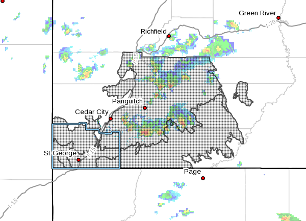
The National Weather Service issued a flash flood watch for most of the southwestern corner of Utah Thursday. Some areas that are expected to receive heavy rains and flash floods include all of Washington County, Cedar City, Brian Head, Kanab, Escalante, Loa, Panguitch, Bryce Canyon National Park and Zion National Park.
An official flash flood warning, which is one step beyond a flash flood watch, has been issued by the weather service for Kane County and Clark County, Nevada. The flash flood watch lasts from noon until 11 p.m.
Bookmark this page for continuous updates about storms and flash flood conditions in Southern Utah Thursday
- Update 4:15 p.m. A flash flood warning has been issued for south-central Iron County. Intense rainfall has produced a debris flow over state Route 14 leading from Cedar Breaks National Monument to Cedar City. The road is closed at mile post 5 near Cedar City. Officials are asking drivers to avoid SR-14 for the “foreseeable future.”
- Update 5:30 p.m. Another flash flood warning has been issued for the Hildale and Colorado City area. Flash flooding is expected in the Short Creek drainage.
- Update 6:50 p.m. The northeastern corner of Washington County, including the Pintura area around New Harmony, has also received a flash flood warning as storms continue to strike Southern Utah.
The thunderstorms sparking the flash flood watch are capable of producing “very heavy rainfall in a short period of time,” according to the weather service.

Areas that are particularly prone to flash floods include the Brian Head burn scar, slot canyons, usually dry washes and small streams. The weather service also warned of possible urban flooding that could cause roads to be flooded.
Urban flash flooding on roads can be messy. A storm last week ripped through Main Street in Washington City and flooded several homes.
Some communities across Southern Utah are already preparing for the storm. In a Facebook post Thursday afternoon, officials from the New Harmony Fire Department said there will be free sandbags available for residents to fill at the New Harmony Fire Station.
“Bring your own shovel,” reads the Facebook post from New Harmony Fire Association.
Many residents in Dammeron Valley, which was hit by a major flash flood July 12, have already received backup sandbags from volunteers to place around their homes.
In a tweet from Zion National Park, park officials said entering the Narrows or other slot canyons are not recommended today.
Flash floods can be deadly, so stay out of washes, canyons and dry river beds when there is a flash flood watch or when heavy rain is forecast.
Email: [email protected]
Twitter: @STGnews | @SpencerRicks
Copyright St. George News, SaintGeorgeUtah.com LLC, 2018, all rights reserved.