ST. GEORGE — Southern Utah residents can anticipate an erratic week of weather with on-and-off rain showers, freezing overnight temperatures in some areas and a warming respite before rain and wind strike again on the weekend.
The National Weather Service in Salt Lake City has issued a hazardous weather outlook for most of the state, also warning of hard freeze conditions and snow in the mountains.
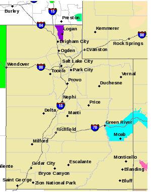
Areas affected
Locally affected areas include Southwest Utah, Utah’s Dixie, Zion National Park, South Central Utah, Glen Canyon Recreation Area/Lake Powell, Central Mountains and Southern Mountains.
Timeline
Showers and isolated thunderstorms across the southern outlook area will taper off Monday evening. Below freezing temperatures are expected tonight in most valleys across the outlook area, except in lower elevation valleys in Southern Utah.
Temperatures in fruit growing areas in the Cache valley area in Northern Utah could see hard freeze conditions with lows dropping into the upper 20s late tonight.

Scattered snow showers are expected over the northeastern outlook area on Tuesday, mainly in the mountains.
Widespread below freezing temperatures will again occur Tuesday night into Wednesday morning outside of the lower elevation southern valleys.
Hard freeze conditions will be likely again in fruit growing areas in the Cache valley and in portions of the Wasatch Front.
A significant warming trend is forecast for the outlook area Wednesday through Thursday. A new series of Pacific storm systems will begin to impact the outlook area Friday with strong gusty winds.
Cooler temperatures and widespread precipitation are expected over the upcoming weekend with significant accumulation of snow possible in the mountains. Snow levels could reach the valley floors by Sunday.
Resources
Email: [email protected]
Twitter: @STGnews
Copyright St. George News, SaintGeorgeUtah.com LLC, 2017, all rights reserved.
For an piece that begins with the words “ST. GEORGE” and appears on a website named “stgeorgeutah.com” this is a remarkably inaccurate portrayal of the weather forecast for St. George. Per http://www.weather.gov, the forecast for St. George, Utah for this week is as follows (retrieved Monday afternoon):
Monday: Hi 61, Lo 39, showers likely this afternoon then clearing tonight
Tuesday: Hi 63, Lo 39, sunny and mostly clear
Wednesday: Hi 71, Lo 47, sunny and mostly clear
Thursday: Hi 79, Lo 51, sunny and mostly clear
Friday: Hi 77, partly sunny
Good morning Bender.
This report reflects an outlook issued by the National Weather Service that is somewhat statewide as the particulars indicate specific areas affected.
The all caps St. George you refer to is the dateline; datelines indicate the location from which we generate a report – in this case, our headquarters; datelines are not summarizing the locale of things mentioned in the story although often the two will coincide if our feet are on the ground at that location (I understand this can seem counterintuitive).
All that said, weather forecasts don’t always agree. For my part, I rather like yours – sunny sunny sunny and partly sunny.
As always, thanks for the opportunity to address things that give you pause. You’re the best. 🙂
ST. GEORGE NEWS
Joyce Kuzmanic
Editor in Chief
Ehhh, thanks for the pro forma reply that does not really address the complaint. Note the first sentence:
“Southern Utah residents can anticipate an erratic week of weather with on-and-off rain showers, freezing overnight temperatures in some areas and a warming respite before rain and wind strike again on the weekend.”
Most of your readership is in St. George. I would not fault a reader for assuming that the above sentence indicates freezing night time temperatures and on and off rain all week in St. George. This is not what NWS had forecast, nor is it what is happening now.
As we all know St. George has a very different climate than the rest of Southern Utah; it’s the reason many of us live here. This article conflates St. George weather with the rest of the state, creating a goulash of a weather outlook which is not useful or accurate. The extreme southwest corner of the state, roughly corresponding with Washington county, almost always has unique weather and your weather forecasts articles should treat it as distinct from the rest of Southern Utah.
Please have your staff, and especially the headline writers, brush up on local geography… they seem to be perpetually lost.
That is a point well taken, distinguishing St. George from Southern Utah as a whole as weather goes (don’t we do that often? Southern Utah is our focus region but St. George is distinct weatherwise). I’ve added your point to my staff meeting agenda, we’ll talk about this.
Gasp! I would never give you a pro forma reply, Bender! 🙂 My replies are specially thought out just for you because … I appreciate and take you seriously.
Joyce
Ha ha Bender …you got told
He’s got a point. When I think ‘southern ut’ I never factor in Cedar bc their weather is far more similar to central or north central ut than the larger st george metro area.