HURRICANE – Sand Mountain in Hurricane is cleaner, safer and easier to navigate thanks to the efforts of local businesses, nonprofits and nearly 60 volunteers who showed up for a National Public Lands Day project Saturday.
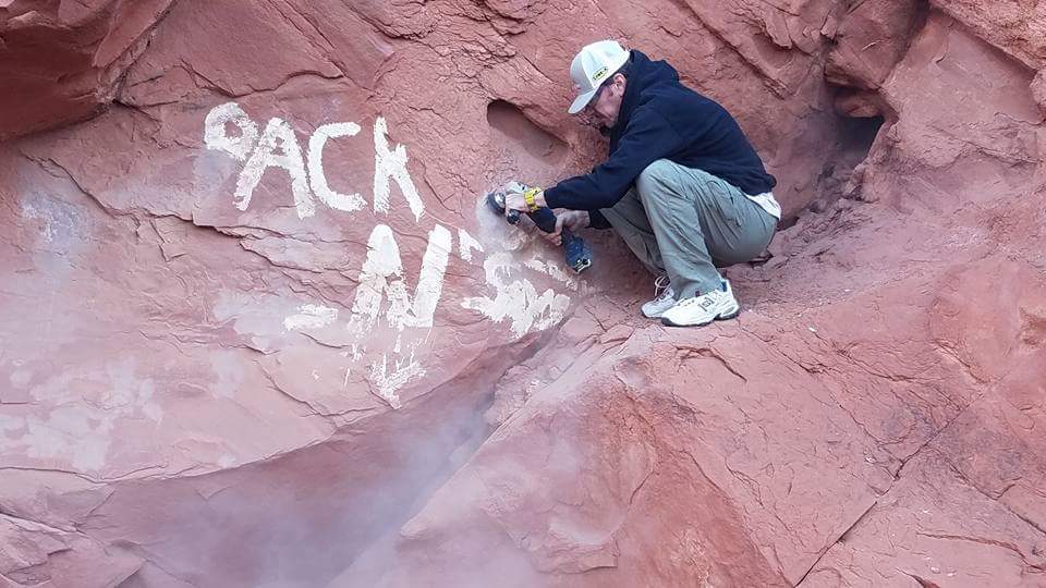
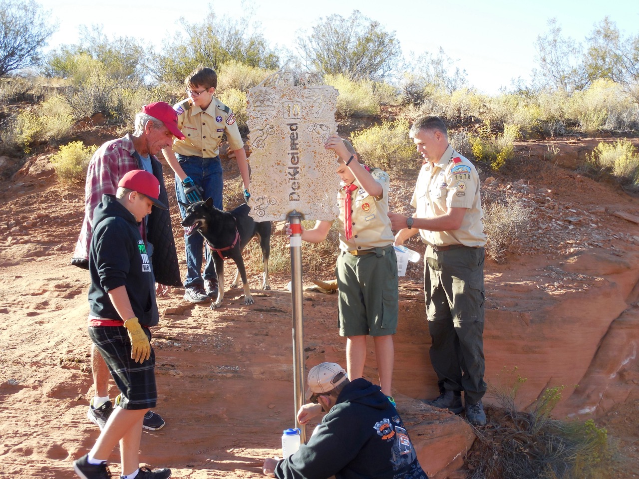
Volunteers, including Boy Scout troops, installed permanent trail marking and “You Are Here” signs, removed graffiti and picked up trash in the popular off-highway vehicle area known to locals as simply Sand Hollow.
“We’re putting signs in so everybody can find the trailheads and (GPS) mapping everything so they know they’re on the trail – where the trail actually starts – so we don’t have people driving just everywhere,” Desert Roads and Trails Society, or Desert Rats, President Jeff Bieber said.
Desert Roads and Trails Society is a 501(c)(3) nonprofit organization that aims to promote and preserve responsible use of public lands. Funds for Saturday’s project came in part through collaboration with the Bureau of Land Management.
Read more: 4×4 help needed for Desert RATS Sand Mountain cleanup, trail sign project
“We like the scenery here and we like to keep it the way it is,” Bieber said. “Even though it is an open OHV area, it’s still a pristine area.”
The Sand Mountain Special Recreation Area is one of the few “open travel” areas designated for off-road use.
Saturday marked the third annual cleanup Desert Rats has sponsored – all of them held on National Public Lands Day. Local residents, however, have been hauling garbage out of the area for a lot longer. Their efforts are paying off as every year’s cleanup day finds less trash on the mountain.
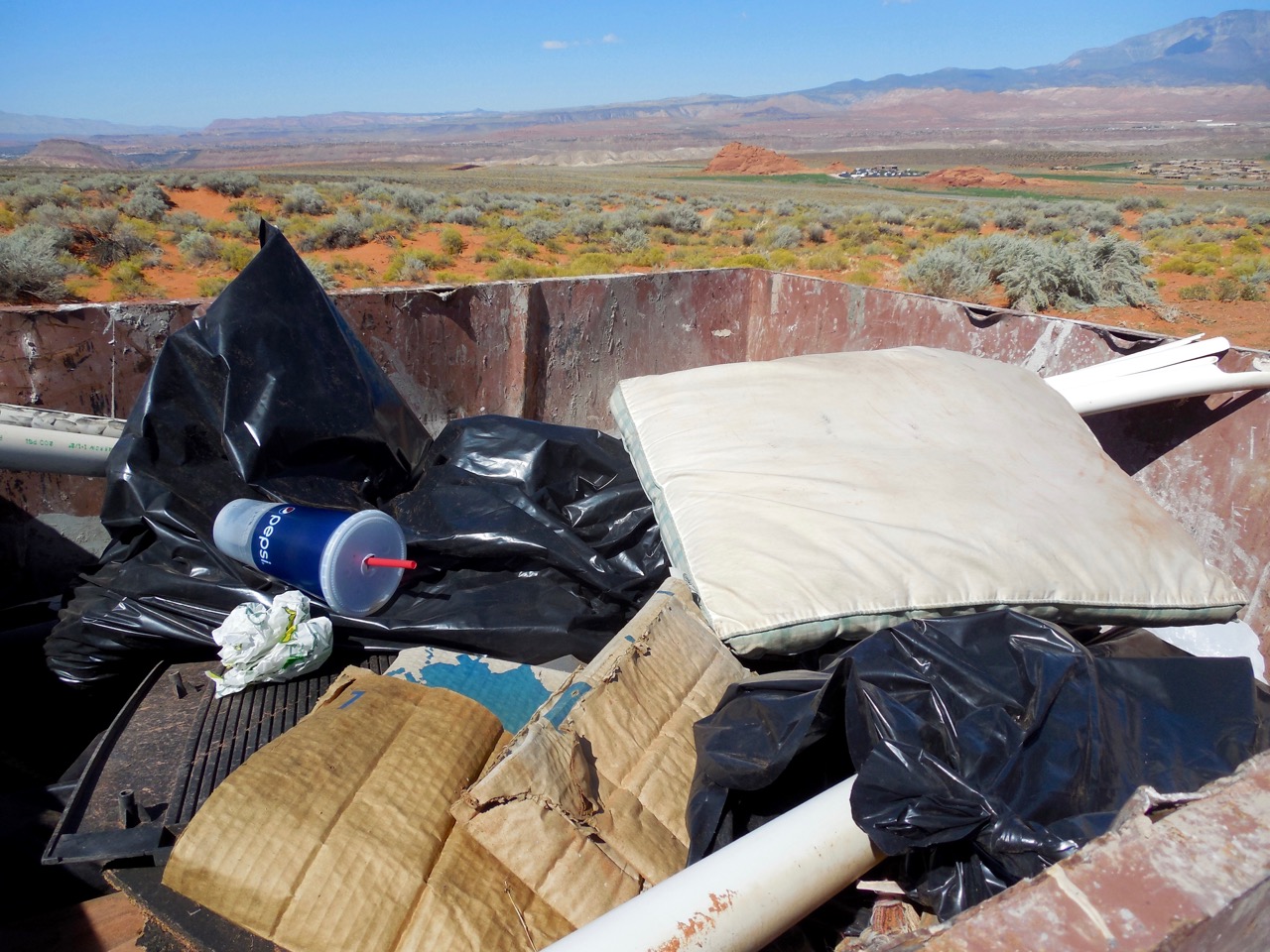
Eight or nine years ago, volunteers filled two 30-yard dumpsters with garbage from Sand Mountain, off-road enthusiast and volunteer Kurt Deissenberger said. Since then, the volume of trash has declined steadily every year.
Desert Rats, Boy Scouts from Troop 1670 of Hurricane, members of Utah Public Lands Alliance, Southwest Adventure Group and local off-road company Dixie 4 Wheel Drive participated in the project.
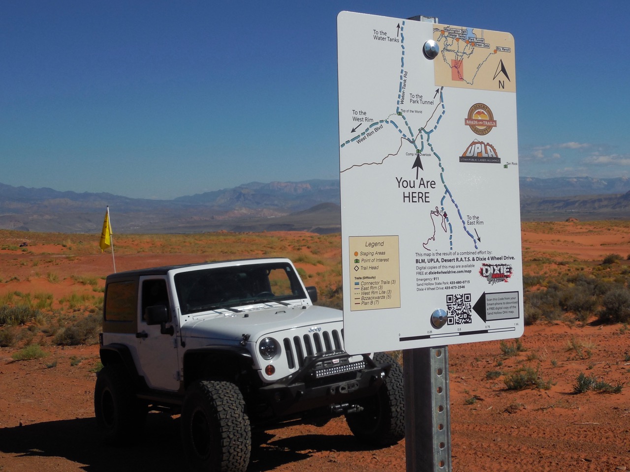
Dixie 4 Wheel Drive placed 14 “You Are Here” signs containing maps of the area which correspond with a new digital map.
The project is a collaborative effort between Dixie 4 Wheel Drive, the Bureau of Land Management, Desert Rats and Utah Public Land Alliance.
The “You Are Here” signs are part of a larger mapping project that has resulted in free maps and a GPS solution for mobile smart phones and tablets, Dixie 4 Wheel Drive spokesman Jim Speth said.
The map of Sand Mountain is available free on the company website and can be downloaded or used with a free PDF map app on mobile devices.
“We want people to feel comfortable understanding the terrain and trails in Sand Hollow. We want to help drivers stay on trails and reduce off-trail impact in the area,” Speth said.
“But most of all, we are excited that these maps are a safety tool for the public as well as the (Sand Hollow) state park and BLM.”
Dixie 4 Wheel Drive spent more than 200 hours plotting, designing and proofing the maps, Speth said.
“UPLA and Desert Rats have many more hours in the collection of GPS tracks, trailhead waypoints, installation preparation,” he added.
Owner and business developer Bryce Thompson of Dixie 4 Wheel Drive is excited about the mapping project.
“I’ve been up here a million times over the last 25 years,” Thompson said, “and every single time (I) run into people that are lost, can’t find their way down, don’t know where they’re at.”
The area was confusing, he said, putting he and others at the business in a position of spending a lot of time on the phone and in person trying to explain where trails are to off-roaders.
“The biggest thing is safety,” Thompson said.
If people are hurt, lost or broken down and don’t know for sure where they are, that can be a big problem.
In addition to safety, Thompson believes that documenting the trails will help keep them open. In the off-roading mecca of Moab, trails that were not clearly marked have been closed down, he said.
Dixie 4 Wheel Drive is also working on kiosks with large area maps in the five Sand Mountain staging areas.
Click on photo to enlarge it, then use your left-right arrow keys to cycle through the gallery.

An enthusiastic group of nearly 60 volunteers turned out early Saturday morning for a cleanup, sign placement and GPS mapping project that makes Sand Mountain safer and easier to navigate, Hurricane, Utah, Sept. 24, 2016 | Photo courtesy of Desert Roads and Trails Society, St. George News


Boy scouts are among the volunteers for a National Public Lands Day project aiming to make Sand Mountain cleaner, safer and easier to navigate, Hurricane, Utah, Sept. 24, 2016 | Photo courtesy of Desert Roads and Trails Society, St. George News

Boy scouts are among the volunteers for a National Public Lands Day project aiming to make Sand Mountain cleaner, safer and easier to navigate, Hurricane, Utah, Sept. 24, 2016 | Photo courtesy of Desert Roads and Trails Society, St. George News

Boy scouts take advantage of a sandy hill while volunteering for a National Public Lands Day project that aiming to make Sand Mountain cleaner, safer and easier to navigate, Hurricane, Utah, Sept. 24, 2016 | Photo courtesy of Desert Roads and Trails Society, St. George News

Boy scouts are among the volunteers for a National Public Lands Day project aiming to make Sand Mountain cleaner, safer and easier to navigate, Hurricane, Utah, Sept. 24, 2016 | Photo courtesy of Desert Roads and Trails Society, St. George News

Boy scouts are among the volunteers for a National Public Lands Day project aiming to make Sand Mountain cleaner, safer and easier to navigate, Hurricane, Utah, Sept. 24, 2016 | Photo courtesy of Desert Roads and Trails Society, St. George News

Boy scouts are among the volunteers for a National Public Lands Day project aiming to make Sand Mountain cleaner, safer and easier to navigate, Hurricane, Utah, Sept. 24, 2016 | Photo courtesy of Desert Roads and Trails Society, St. George News

Boy scouts are among the volunteers for a National Public Lands Day project aiming to make Sand Mountain cleaner, safer and easier to navigate, Hurricane, Utah, Sept. 24, 2016 | Photo courtesy of Desert Roads and Trails Society, St. George News

In this file photo, Boy Scouts are among the volunteers for a National Public Lands Day project aiming to make Sand Mountain cleaner, safer and easier to navigate, Hurricane, Utah, Sept. 24, 2016 | Photo courtesy of Desert Roads and Trails Society, St. George News

Graffiti removal is part of the National Public Lands Day cleanup and mapping project Saturday sponsored by the Desert Roads and Trails Society, Hurricane, Utah, Sept. 24, 2016 | Photo courtesy of Desert Roads and Trails Society, St. George News

New signs and GPS mapping make Sand Mountain safer and easier to navigate, Hurricane, Utah, Sept. 24, 2016 | Photo courtesy of Desert Roads and Trails Society, St. George News

New signs and GPS mapping make Sand Mountain safer and easier to navigate, Hurricane, Utah, Sept. 24, 2016 | Photo courtesy of Desert Roads and Trails Society, St. George News

New signs and GPS mapping make Sand Mountain safer and easier to navigate, Hurricane, Utah, Sept. 24, 2016 | Photo courtesy of Desert Roads and Trails Society, St. George News

New signs and GPS mapping make Sand Mountain safer and easier to navigate, Hurricane, Utah, Sept. 24, 2016 | Photo courtesy of Desert Roads and Trails Society, St. George News

New signs and GPS mapping make Sand Mountain safer and easier to navigate, Hurricane, Utah, Sept. 24, 2016 | Photo courtesy of Desert Roads and Trails Society, St. George News

Volunteers place signs at the Oasis on Sand Mountain. New signs and GPS mapping make Sand Mountain safer and easier to navigate, Hurricane, Utah, Sept. 24, 2016 | Photo courtesy of Desert Roads and Trails Society, St. George News

New signs and GPS mapping makes Sand Mountain safer and easier to navigate, Hurricane, Utah, Sept. 24, 2016 | Photo courtesy of Desert Roads and Trails Society, St. George News

Jeeps gather at Top of the World at Sand Mountain. New signs and GPS mapping make Sand Mountain safer and easier to navigate, Hurricane, Utah, Sept. 24, 2016 | Photo courtesy of Desert Roads and Trails Society, St. George News

New signs and GPS mapping make Sand Mountain safer and easier to navigate, Hurricane, Utah, Sept. 24, 2016 | Photo courtesy of Desert Roads and Trails Society, St. George News

Garbage picked up by volunteers during a National Public Lands Day project Saturday, Hurricane, Utah, Sept. 24, 2016 | Photo courtesy of Desert Roads and Trails Society, St. George News
Email: [email protected]
Twitter: @STGnews
Copyright St. George News, SaintGeorgeUtah.com LLC, 2016, all rights reserved.
Good work! Thank you!
It’s a good thing. They’re not inmates out there doing community service eh ? because I’m sure you would ” really oppose ” that also. !