LIVE: This weather advisory is being updated periodically throughout the day. Bookmark and refresh page for updates. Last update 5:21 p.m. This weather LIVE report is completed.
- 5:21 p.m. – Heavy rain is expected to produce flooding in the St. George metropolitan area. Extended rainfall is predicted. Take adequate precautions. Turn around, don’t drown.
- 4:32 p.m. – Mesquite, Nevada and surrounding areas:
The National Weather Service in Las Vegas has issued a severe thunderstorm warning for northwestern Mohave County in northwestern Arizona, northeastern Clark County in southern Nevada and southeastern Lincoln County in south central Nevada. The alert is active from 3:30 p.m. PDT, 4:30 p.m. MDT, until 4:30 p.m. PDT, 5:30 p.m. MDT.
Doppler radar indicted severe thunderstorms capable of producing quarter-size hail and damaging winds in excess of 60 mph are expected.
These storms are located along a line extending from 7 miles south of Bunkerville, Nevada, to 6 miles southwest of Echo Bay Campground, Nevada, and are moving northeast at 30 mph. This storm will produce lightning and high winds which can bring down trees and power lines and cause blowing dust.
Mesquite, Beaver Dam, Littlefield, the Virgin River Gorge, Moapa Valley, Temple Bar Campground, Overton Beach, the Virgin River Campground, Echo Bay, Bunkerville, the Echo Bay Campground and the Valley of Fire and Temple Bar are all affected by this alert.
The following highways are also in the line of this severe thunderstorm: Interstate 15 in Arizona between mile markers 0 and 29; Interstate 15 in Nevada between mile markers 106 and 120.
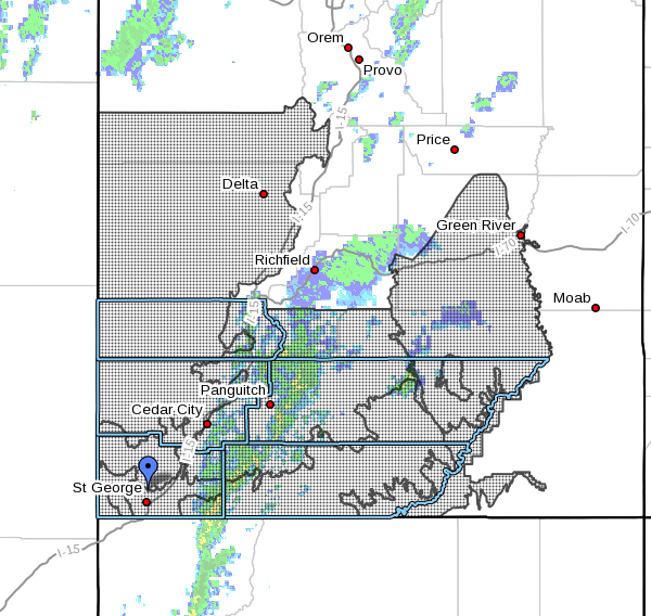
- 10:50 a.m. – Local flash flood warnings expanded to areal advisory affecting most of southern and eastern Utah.
SOUTHWEST UTAH – Southwest Utah can expect a windy day Thursday, compounded by heavy rainfall that puts areas across most of southern and eastern Utah at risk of flash flooding.
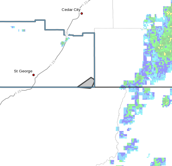
A thunderstorm indicated on Doppler radar at 7:45 a.m. showed torrential rain moving over Hildale and the drainages above that region and Zion National Park. According to the National Weather Service’s morning alert, radar estimates were underestimating the heavy rainfall that occurred but automated gauges and local reports indicated in excess of 1 inch of rain had fallen across those areas.
Additionally, at 10:14 a.m. multiple waterways throughout southern and central Utah are flooding.
Heavy rainfall will continue at times across southwest Utah through the evening hours with strong thunderstorms expected to develop later Thursday afternoon, according to an areal advisory issued by the weather service around 10 a.m.
The additional rainfall will exacerbate the already flooded waterways, the service advisory said.
Timing
The wind advisory issued by the weather service is in effect until 11 p.m. Thursday.
Flash flood warnings are in effect until 10:15 p.m. Thursday.
Affected areas
The predicted winds will affect west-central and Southern Utah, including Delta, Cedar City, St. George, Bryce Canyon, Kanab, Hanksville and Lake Powell.
Hildale, Utah, and Colorado City, Arizona are particularly susceptible to flash floods Thursday morning, including short Creek and washes that feed into the creek. The east fork of the Virgin River, Refrigerator and Echo canyons as well as other slot canyons across the southern and eastern portions of Zion National Park are also subject to flash flooding.
Areal flood advisory specifies: Price, Kanab, Escalante, Hanksville, St. George, Washington, Hurricane, LaVerkin, Capitol Reef National Park, Helper, Huntington, Wellington, Big Water, Sunnyside, Henrieville, Boulder, Torrey, Clawson, hatch and Halls Crossing
.Winds
Southwest 30-mph winds with gusts around 50 mph are forecast for the affected areas in west-central and Southern Utah.
Impacts
Strong crosswinds may impact travel especially for high profile vehicles and those towing trailers.
Wind sensitive operations may be impacted.
High winds will cause hazardous boating conditions.
Precautionary/preparedness actions
Motorists in the advisory area should be prepared for sudden gusty crosswinds which can make driving difficult.
- Read more: Caught on camera: High winds overturn semi on I-15 – 2016
Boaters on area lakes can expect gusty winds, very choppy water, large waves, dangerous lightning and poor visibility in heavy rain. Boaters should seek safe harbor immediately.
- Read more: 1 boat capsizes during extreme weather on Lake Powell – 2015
Most flood deaths occur in vehicles and even more so at nighttime. According to the National Weather Service, more people die during floods than any other single severe weather hazard and offer the following steps to mitigate the dangers:
- Do not drive onto a flooded roadway.
- Do not drive through flowing water.
- If approaching a roadway that is flooded, turn around, don’t drown.
- Drive with extreme caution if roads are wet or it is raining. It is possible to lose control of a vehicle once it begins to hydroplane (when water builds up between the tires and the road surface).

In Thursday’s midmorning area warning, the National Weather Service out of Salt Lake City warned:
If you are near any waterway in the warned area, understand these areas are incredibly dangerous and will continue to be a hazard through the nighttime hours. Please use prduent judgement when traveling around these ares.
If a flash flood warning is issued for your area:
- If advised to evacuate, do so immediately! Get out of areas that are subject to flooding and move to a safe area before access is cut off by flood waters. Low spots such as dips, canyons and washes are not safe places to be during flooding.
- Do not camp or park your vehicle along streams and washes, particularly during threatening conditions.
- Do not drive unless absolutely necessary. If driving is absolutely necessary, do not attempt to drive over a flooded road, as the depth of the water is not always obvious, and the roadway may not be intact under the water.
- Never drive around a barricade, they are placed their for your protection. If your vehicle stalls, leave it immediately and move to higher ground before water sweeps you and your vehicle away.
- Do not try to walk, swim or play in flood water. You may not be able to determine if there are holes or submerged debris, or how quickly the water is flowing and you may be swept away. If water is moving swiftly, as little as 6 inches of water can knock you off your feet.
- There is also a danger from hazardous material polluting water.
- Remember that water is an electrical conductor — if there are power lines down, there is a possibility of electrocution.