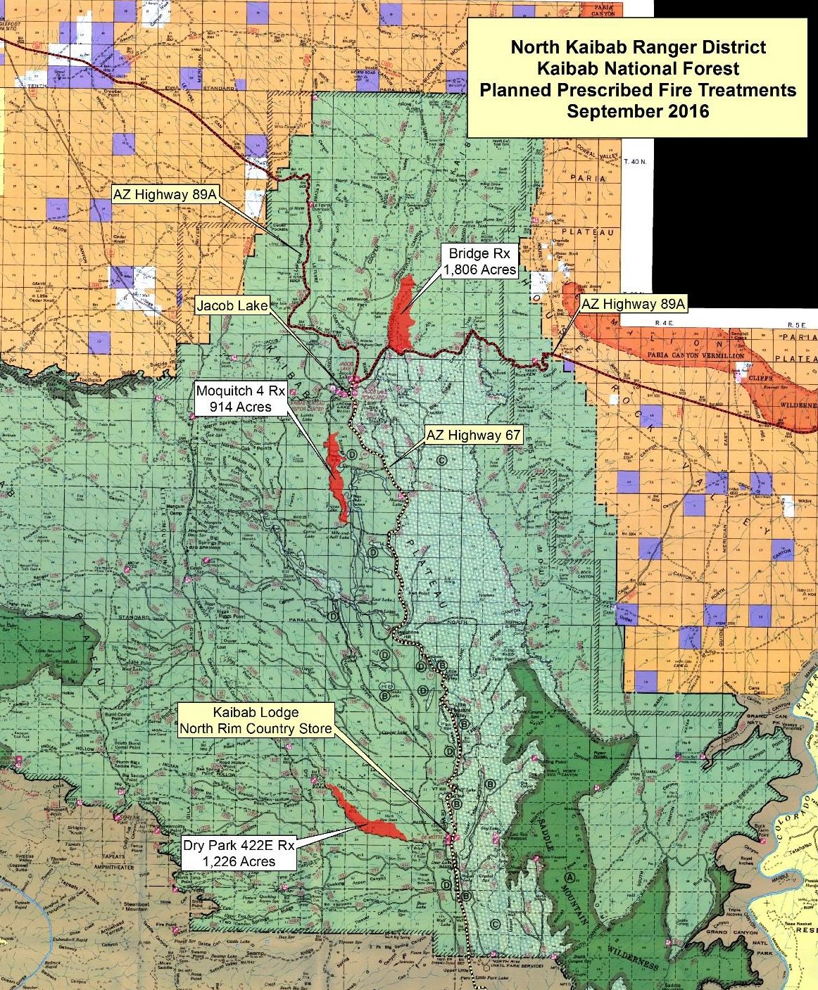
FREDONIA, Ariz. — Fire managers for the North Kaibab Ranger District of the Kaibab National Forest plan to ignite prescribed fires to reduce hazardous fuels at various locations across the district as early as Tuesday.
The specific prescribed fire units to be ignited will be chosen based on weather and fuel conditions and may include the following:
- Jacob Ryan Bridge Unit: Approximately 1,806 acres
- Moquitch 4 Unit: Approximately 914 acres
- Dry Park 422E Unit: Approximately 1,226 acres
Smoke possible in areas
During prescribed fire operations, community members and forest visitors may see fire personnel and vehicles in the vicinity.
Smoke may be visible from U.S. Highway 89A and U.S. Highway 67 within the vicinity of Jacob Lake, Houserock Valley and Marble Canyon; however, fire managers strive to minimize smoke impacts to the community as much as possible.
Smoke is expected to disperse to the northeast during the day, and residual smoke may settle into drainages and low lying areas overnight but should dissipate quickly as fire managers will only commence ignitions when conditions exist that will allow smoke to adequately ventilate.
Prescribed fires are essential tools for restoring the forests in a fire-adapted ecosystem, and smoke is an unavoidable byproduct of these efforts.
Prescribed fire operations occur when winds and other atmospheric conditions will push the majority of smoke away from communities and ultimately limit the number of days smoke lingers.
All prescribed burning on the Kaibab National Forest is subject to approval by the Arizona Department of Environmental Quality and appropriate weather conditions.
Notifications of upcoming prescribed burns will be provided regularly throughout the season.
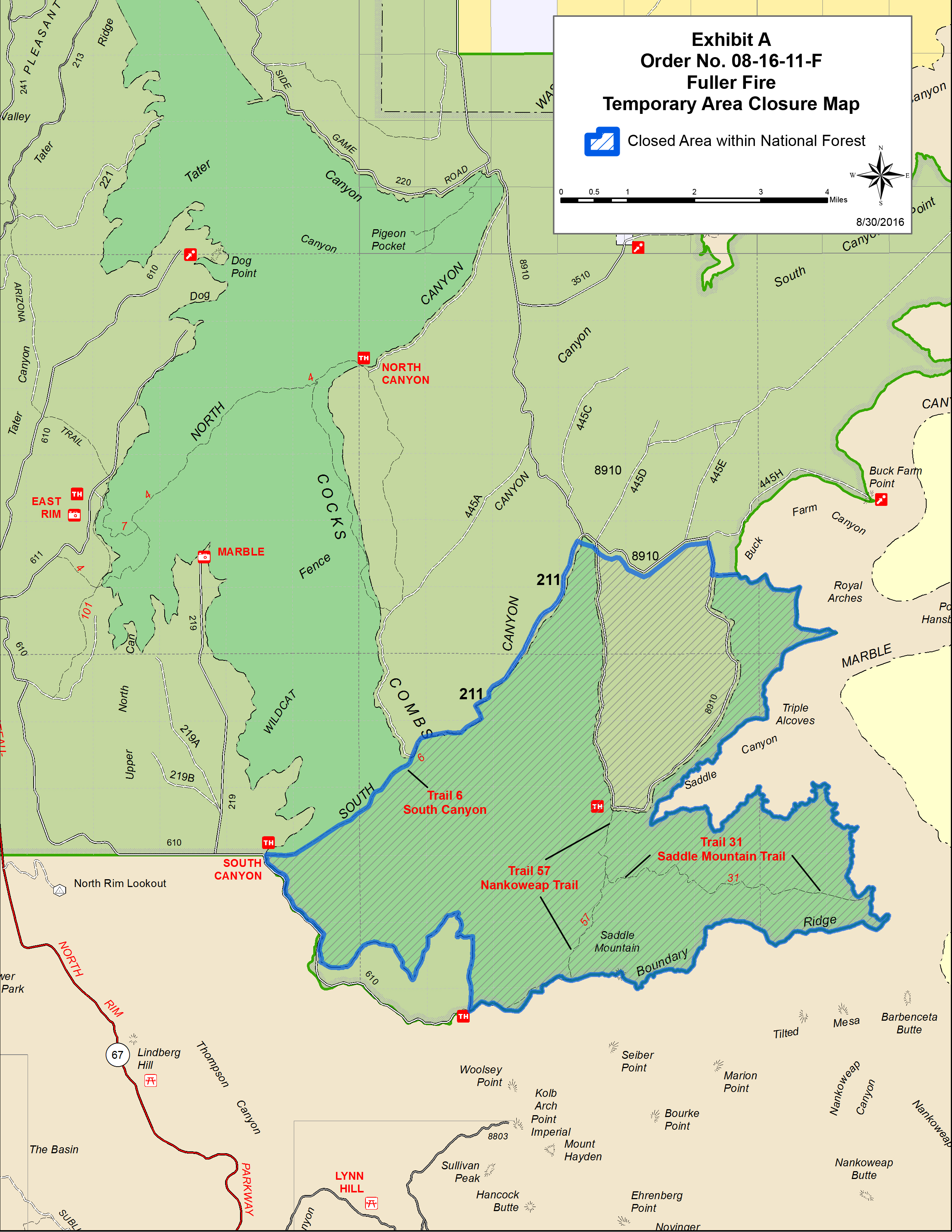
Road and trail closures related to Fuller Fire in Saddle Mountain Wilderness
An area in the southeastern portion of the North Kaibab Ranger District in the vicinity of the Saddle Mountain Wilderness has been closed to public entry due to the Fuller Fire, which began
The area subject to the closure order was reduced Sept. 1 but is expected to remain in place until Sept. 30. This includes closure of roads and trails in the area.
The boundary of this area closure starts east of Highway 67 at the South Canyon Trailhead off Forest Road 610, heading northeast along South Canyon Trail No. 6 to the junction with Forest Road 211, then continuing northeast along FR-211 to the junction with Forest Road 8910, then just south of F- 8910 heading east, then along the Saddle Mountain Wilderness boundary, and back to the South Canyon Trailhead off FR-610.
Closed roads include FR-211 and the portion of FR-8910 that runs north and south in the closure area.
Trails closed include those within Saddle Mountain Wilderness: South Canyon Trail No. 6, Nankoweap Trail No. 57 and Saddle Mountain Trail No. 31.
Resources
- Additional fire information for Kaibab National Forest can be obtained through the Kaibab National Forest Fire Information Phone Line 928-635-8311 or via text message – text ‘follow kaibabnf’ to 40404.
- Southwest Fire Consortium’s video: Keeping Fire on the Ground: Resource Specialist Perspectives on the Kaibab National Forest
Email: [email protected]
Twitter: @STGnews