Eyewitness storm video courtesy of Brett Bourne
COCONINO COUNTY, Ariz. – Arizona Department of Transportation crews from Fredonia, Page and Gray Mountain, Arizona, are working to reopen Highway 89-A Monday. A 34-mile stretch of road was shut down Sunday afternoon after flooding from a massive storm washed mud and boulders across the highway between Marble Canyon, Arizona, and Jacob Lake, Arizona.
“There are boulders the size of houses on the road,” a desk clerk at Cliff Dwellers Lodge, near the slide area, said.
Read more: UPDATE: Flood closure area partially reopens on Highway 89-A
A road closure is in place beginning 5 miles west of Marble Canyon, at milepost 545, and ending at Jacob Lake, at milepost 579, according to information from ADOT.
Crews worked through the night Sunday to commence clearing the debris, according to information from ADOT. As of 2 p.m. MDT Monday, ADOT did not yet have an estimate for when the road will be reopened.
Brett Bourne, of Perth, Australia, was traveling on Highway 89-A on a motorcycle when the storm hit that caused the flooding and subsequent road closure.
“It was probably the heaviest rain that I’ve ever ridden through,” Bourne said.
Bourne has been traveling in the United States with his son and three friends. He was riding alone, however, traveling toward the Grand Canyon when the storm hit.
Bourne said heavy rain and hail started coming down while he was riding on Highway 89-A. The storm became so intense that he had to cover his face with his riding glove, and visibility became so poor that he had to stop at one point.
He stopped on a bridge, he said, and muddy water was raging below him. Large rocks were washing up and hitting the pipes beneath the bridge. Waterfalls were cascading from the tops of the nearby cliffs.
“I’ve been riding for 30 years, I suppose – 40 years,” Bourne said, “and I’ve never hit rain like that before.”
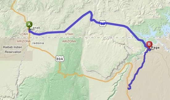
Anyone needing to travel through the closure area must detour via Highway 89 through Page, Arizona, and Kanab, Utah. (See accompanying map for detour information.)
Those traveling to the Grand Canyon’s North Rim should travel through Kanab and then take Highway 89-A through Fredonia, Arizona, and up to Jacob Lake.
Resources
Click on photo to enlarge it, then use your left-right arrow keys to cycle through the gallery.

A 34-mile road closure follows heavy storms in Coconino County, Arizona, Aug. 10, 2015 | Photo courtesy of Arizona Department of Public Safety, St. George News

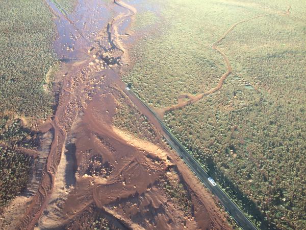
Aerial image of road closure area, Coconino County, Arizona, Aug. 10, 2015 | Photo courtesy of Arizona Department of Public Safety, St. George News

Mud and boulders cover Highway 89-A after heavy storms in Coconino County, Arizona, Aug. 9, 2015 | Photo courtesy of Arizona Department of Transportation, St. George News

Mud and debris cover Highway 89-A following heavy storms in Coconino County, Arizona, Aug. 9, 2015 | Photo courtesy of Arizona Department of Transportation, St. George News

Mud and boulders cover Highway 89-A after heavy storms in Coconino County, Arizona, Aug. 9, 2015 | Photo courtesy of Arizona Department of Transportation, St. George News

Highway 89 detour | Image created on Mapquest.com, St. George News

Arizona Department of Transportation crews man an all-night roadblock on Highway 89-A, Jacob Lake, Arizona, Aug. 9, 2015 | Photo by Cami Cox Jim, St. George News
Related posts
- Landslide shuts down Highway 89-A; alternate route
- US Highway 89 south of Page reopens after 2013 landslide
- STORM LIVE: Thunder rolls, lightning strikes, storms pound So. Utah; STGnews Video, Photos
- Flooding, thunder, lightning: Storms rage in So. Utah; STGnews Photo Gallery
Email: [email protected]
Twitter: @STGnews
Copyright St. George News, SaintGeorgeUtah.com LLC, 2015, all rights reserved.
Would’ve been awesome to see that rockslide
As big as houses? Maybe teardrop trailers. But houses? Nooooooo
True
Maybe little houses or real big trailers