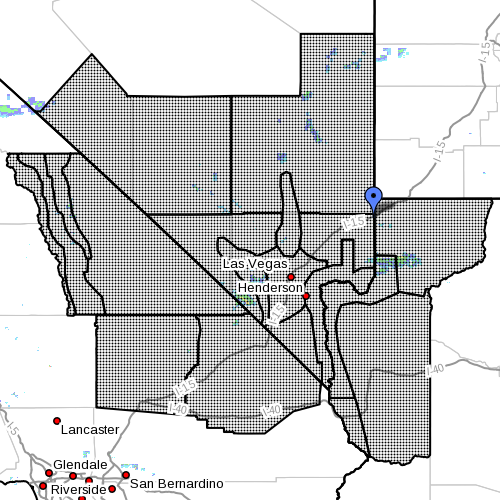
MESQUITE, Nev. — The National Weather Service in Las Vegas has issued a “flash flood watch” for portions of northwest Arizona, southeast California and Nevada from 11 a.m. PDT and PST, noon MDT, through Friday evening. While there are presently no alerts or hazardous outlooks issued by the NWS in Salt Lake City for Utah, weather doesn’t always respect borders and Southern Utah, bordering the watch area, could experience some of the same.
A high moisture content remains in place in the atmosphere across the area, the NWS said. Any stronger or slower moving thunderstorms could unleash heavy rainfall in a quick period of time. Rainfall totals of 1-2 inches in an hour or less, with locally higher amounts, are possible in some cases.

Affected areas
Northwest Arizona: Lake Havasu, Fort Mohave, Lake Mead National Recreation Area, northwest deserts and northwest plateau
Southeast California: Death Valley National Park, Eastern Mojave Desert, Eastern Sierra Slopes, Owens Valley, Western Mojave Desert and White Mountains of Inyo County
Nevada: Esmeralda and Central Nye County, Lake Mead National Recreation Area, Las Vegas Valley, Lincoln County, Northeast Clark County, Sheep Range, Southern Clark County, Spring Mountains-Red Rock Canyon, Western Clark County and Southern Nye County
Impacts
Roads could be closed due to water flowing over them, as well as mud and rocks washing into them. Roadway pavement may be washed away. Some dirt and secondary gravel roads could be washed out. Rapid rises in washes could also occur, leading to flash flooding downstream. Any burn areas, such as the Carpenter 1 Burn Area on Mount Charleston, could also see debris flows take place if heavy rain falls or runs onto the burned landscape.
Precautionary, preparedness actions
Remain alert for flooding even in locations not receiving rain. Dry washes, streams and rivers can become raging killer currents in a matter of minutes, even from distant rainfall.
Move to higher ground now. Act quickly to protect your life.
Do not drive your vehicle into areas where the water covers the roadway. The water depth may be too great to allow your car to cross safely.
READ MORE: I can’t believe I survived; video of flash flood crashing down on canyoneers
Turn around. Don’t drown.
The National Oceanic and Atmospheric Association and the National Weather Service offer safety rules for flash flooding:
- Flash flooding is a very dangerous situation
- Flash flood waves, moving at incredible speeds, can roll boulders, tear out trees, destroy buildings and bridges and scour out new channels. Killing walls of water can reach heights of 10 to 20 feet. You will not always have warning that these deadly, sudden floods are coming. When a flash flood warning is issued for your area or the moment you first realize that a flash flood is imminent, act quickly to save yourself. You may have only seconds.
- Most flood deaths occur in automobiles. Do not drive your vehicle into areas where the water covers the roadway. Flood waters are usually deeper than they appear. The road bed may not be intact under the water. Just one foot of flowing water is powerful enough to sweep vehicles off the road. If the vehicle stalls, abandon it immediately and seek higher ground. Rapidly rising water may engulf the vehicle and its occupants and sweep them away
- Do not hike rivers and especially slot canyons while flash flood warnings are in place
- Do not hike alone and always tell someone where you and your buddy and others are going
- Get out of areas subject to flooding, including dips, low spots, canyons and washes
- Avoid already flooded and high velocity flow areas. Do not try to cross a flowing stream on foot where water is above your knees
- Be especially cautious at night when it is harder to recognize flood dangers
- Do not camp or park your vehicle along streams and washes, particularly during threatening conditions
Read more: Rescue commander tells how to survive a flash flood
During any flood emergency, stay tuned to your NOAA weather radio, commercial radio or television, follow St. George News at STGnews.com and St. George News Facebook for weather alerts and updates relevant to Southern Utah. Information from the National Weather Service and disaster and emergency services may save your life.
Related posts
- Flash floodFlash Flood Watch issues for Southern Utah counties watch across 3 Western states
- What to do before, during, after a flash flood
- I can’t believe I survived; video of flash flood crashing down on canyoneers
Email: [email protected]
Twitter: @STGnews
Copyright St. George News, SaintGeorgeUtah.com LLC, 2015, all rights reserved.
I’m often amazed at how flood watches, etc, magically stop at the Utah Border…
holy land of zion don’t get flooded
It’s by the grace of the anointed one. you just don’t mess with the Zion Curtain
Free bag. You “both” need help.
Aww you poor little baby why don’t you come sit in mommies lap and tell me about it my huggy wuggies
I love it.!