ST. GEORGE – The National Weather Service in Salt Lake City has issued a “High Wind Warning” for western and southwestern Utah from 6 a.m. Tuesday through 11 p.m. Wednesday.
The western half of the state from Iron County northward will be largely impacted 10 a.m. to 11 p.m. Tuesday. The High Wind Warning covering Washington, Iron, Kane, Garfield and Beaver counties is anticipated to run from 6 a.m. Tuesday to 11 a.m. Thursday.
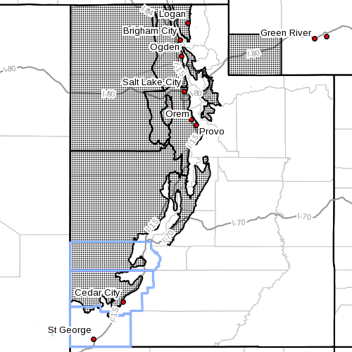
Affected Areas
From 10 a.m. to 10 p.m. Tuesday, areas projected to be impacted by high winds include the western and central valleys of Utah, along with southwest Wyoming.
The warning includes Cache Valley, northern Wasatch Front, Salt Lake and Tooele valleys, southern Wasatch Front, Great Salt Lake desert and mountains, Wasatch Mountain valleys, Sanpete and Sevier valleys, west-central Utah, southwest Utah, and southwest Wyoming, including the cities of Logan, Smithfield, Brigham City, Ogden, Bountiful, Salt Lake City, Tooele, Lehi, Provo, Nephi, Wendover, Snowville, Huntsville, Park City, Heber City, Manti, Richfield, Delta, Fillmore, Beaver, Cedar City, Milford and Evanston.
From 6 a.m. Tuesday to 11 a.m. Wednesday, a High Wind Warning will be in effect for Beaver, Garfield, Iron, Kane and Washington counties.

This warning covers the Southern Utah mountains and eastern and southern valleys, the western Uinta Basin, Castle Country, San Rafael Swell, Utah’s Dixie and Zion National Park, south-central Utah, and the Glen Canyon Recreation Area/Lake Powell area. This also includes the cities of Loa, Panguitch, Bryce Canyon, Duchesne, Roosevelt, Price, Castle Dale, Emery, Green River, Hanksville, the St. George area, Kanab, Escalante and Bullfrog.
Winds
Western Utah Tuesday
Strong and quite gusty southwesterly winds are expected to develop by mid-morning Tuesday. Winds will shift to the northwest and strengthen behind a strong cold front mid-to-late Tuesday morning across the west desert, and Tuesday afternoon and evening further across the rest of northern and central Utah valleys and southwest Wyoming. Gusts exceeding 60 mph are expected and may locally reach 70 mph across the west desert and point of the mountain in northern Utah County through the evening hours.
Tuesday-Wednesday
Southwest winds may gust is excess of 60 mph from mid-morning Tuesday into the early evening hours. Winds will switch to the northwest and remain strong Tuesday night and may remain strong into Wednesday morning especially in areas prone to gusty northwest winds.
Wind will continue into Wednesday morning, especially in areas prone to gusty northwest winds. Very strong southwest winds may gust in excess of 75 mph at the higher elevations by Tuesday afternoon. Winds will shift to the northwest Tuesday evening and remain gusty through Wednesday morning.

Impacts
Strong crosswinds will affect travel for high profile and light-weight vehicles, including Interstates 80 and 15. Wind sensitive operations will be impacted.
Take the opportunity to secure loose items before the winds arrive Tuesday. Visibilities may be reduced in areas of blowing dust. In addition, winds will cause rough choppy waters on area lakes. Small boats will be especially prone to capsizing.
Those traveling through the southern mountains should plan for very strong winds, especially in the vicinity of Brian Head and Boulder Mountain.
Precautionary and preparedness actions
A high wind warning means a hazardous high wind event is expected or is occurring. Sustained wind speeds of at least 40 mph or gusts of 58 mph or more can lead to property damage.
Vehicles, especially high profile vehicles, can be difficult to control at times in high winds. Motorists should take extra caution, especially while crossing bridges, overpasses and un-sheltered areas.
The strong winds will create dangerous boating conditions on area lakes. These winds will create very choppy water and generate large waves which could capsize or swamp small craft. For your personal safety, operators of small craft are urged to postpone their outings until the winds subside.
Related posts
- NWS issues wind advisory for Southern Utah; travel impacts
- What the haze? National Weather Service explains strange haze over So. Utah
- National Weather Service issues ‘Hard Freeze Watch’
- High winds flip double-wide trailer on state Route 17DSU Sustainability Club holds clean air rally
Email: [email protected]
Twitter: @MoriKessler
Copyright St. George News, SaintGeorgeUtah.com LLC, 2015, all rights reserved.