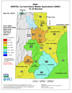
ST. GEORGE – After what may seem like weeks of rain, and lots of fresh snow in the mountains, how is the water outlook for Washington County?
Better, but not great, said Ron Thompson, general manager of the Washington County Water Conservancy District.
See videocast, hit the play arrow  top of this report.
“The storm put down nearly 5 inches of water in the snow pack at Kolob, for example, and we don’t see very many of those kinds of storms,” Thompson said.
“At least it’s positive; now, if we were to get two or three more (storms) before the end of the month … then we’ll be great. Great’s probably not the right word, but we’ll be OK,” he said.
Despite recent storms, Southern Utah is still in a drought situation.
“Whether you believe in climate change or not,” Thompson said, “there’s something different in this climate pattern the last, particularly, decade that gives you – you better be prepared for it – because as a water manager, you better address it in your long-term plans. That’s what we’re trying to do here.”
Thompson said the county is in its fourth year of significantly below-average snow, and that translates into less water in its rivers and reservoirs.
“But, you know,” Thompson said, “it’s nice to see the river at least getting back up to over 50 percent of what we normally see this time of year.”
This summer, Washington County residents can expect time-of-day watering restrictions to be implemented by communities, typically limiting outside water use to the hours of about 8 p.m. to 8 a.m., Thompson said.
Agricultural water restrictions are also expected this year. Last summer, a number of water users along the Virgin River and its tributaries had to stop irrigating.
Even with the recent storms, Thompson encourages residents to conserve water when possible.
“The water we save today will be here tomorrow,” Thompson said. “We need to be cautious and wise with our water use.”
Another concern is how fast the spring runoff comes down.
The speed at which the spring runoff occurs is important, not just because of flooding concerns, but also because both Sand Hollow and Quail Creek reservoirs are off-stream facilities; that is, they don’t directly capture runoff water.
Instead, water is piped from the rivers into the reservoirs, and so the amount that can be captured is limited by the size of the pipes. During a fast runoff, which happens if high temperatures hit quickly, much of the runoff is lost downstream.
“If it all comes off in a week, instead of over six weeks, you only capture a small part of it,” Thompson said of the runoff. “Whereas if it comes down more slowly, you may pick up 70 to 80 percent of it.”

Due to uneven and broken topography, the county does not have a landscape that is appropriate for in-stream reservoirs.
“We’re not blessed here with a lot of reservoir sites, either on-stream or off-stream,” Thompson said.
Gunlock Reservoir is an in-stream reservoir, but has a much lower capacity than Sand Hollow and Quail Creek, and only fills up about 2 out of every 10 years.
One alternative to having in-stream reservoirs is storing water underground. The district has an active recharge basin project, which already contains more than 100,000 acre-feet of water, out of a potential storage of 350,000 acre feet. One acre-foot is equal to about 325,000 gallons.
The district is adding 10,000 acre-feet per year to the underground storage, Thompson said. The water can be pumped back out of the ground for use by county residents, if needed.
Flood potential?
While there is a lot more snow in the mountains than there was earlier in the winter this year, currently the risk of spring flooding is low, Washington County Public Works Director Ron Whitehead said.
“All of our reservoirs are really low,” Whitehead said, ” … so we have plenty of capacity to store that water as it comes down.”
A flood like the one experienced by the county in 2005 is unlikely this year given there is not much snow in the region. The county desperately needed the moisture from recent storms, Whitehead said. Before the recent storms, there was essentially no snowpack.
Some of the county’s waterways were damaged by flooding in 2010. Repair work to those waterways is nearly completed, Whitehead said, noting Shem Dam was the last project. Repairs were funded by the Natural Resources Conservation Service, a federal program for emergency watershed protection projects.
Resources
- Washington County Water Conservancy District website
- USDA Natural Resources Conservation Service Utah Water Data webpage
- Washington County Public Works Department webpage
Related posts
- Flood-damaged historic Shem Dam threatens bridges; rehabilitation bid awarded
- Water Conservancy District aims for spring opening of $1M Red Hills Desert Garden
- Red Hills Desert Garden showcases endangered species, promotes water conservation
- State officials mandate Virgin River water cuts; future uncertain, 2014
- Water District invests $1 million in Quail Creek Diversion aging infrastructure; video, 2014
Email: [email protected]
Twitter: @STGnews
Copyright St. George News, SaintGeorgeUtah.com LLC, 2015, all rights reserved.