UPDATED: 1:30 p.m. Sunday
SOUTHERN UTAH — The National Weather Service in Salt Lake City has issued a “Winter Weather Advisory” for Washington, Iron, Kane, Garfield and Beaver counties in effect from 5:04 a.m. Sunday through 4 p.m. Tuesday.
Affected area
The Wasatch Plateau and Book Cliffs and the central and southern mountains of Utah.
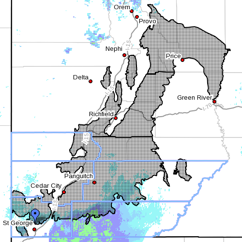
Snow accumulations
New accumulation of 1 to 2 feet is expected by Tuesday afternoon. Local amounts around 3 feet are possible at the higher elevations in the southern mountains.
Timing
Snow will become widespread in the southern mountains by midday Sunday then spread north through the central mountains and across the Wasatch Plateau Sunday night. The snow will continue through Monday night and into Tuesday before tapering off Tuesday afternoon.
Impacts
Winter driving conditions can be expected on area roadways including Highway 6 through Soldiers Summit and the higher passes of Interstate 70, Interstate 15 and Highway 89 across central and Southern Utah.
Precautionary preparedness actions
A Winter Weather Advisory for snow means that snow accumulations will cause primarily travel difficulties. Be prepared for snow covered roads. Use caution while driving.
Spotter information
Weather spotters are encouraged to report significant weather conditions according to standard operating procedures.
For more information visit the National Weather Service website or for information regarding potential road travel impacts visit the Utah Department of Transportation website.
Related Stories
- Road weather alert cautions drivers of threatening conditions; check before traveling
- Travelers beware: Winter weather, snow, avalanche warnings issued
Email: [email protected]
Twitter: @NewsWayman
Copyright St. George News, SaintGeorgeUtah.com LLC, 2015, all rights reserved.