IVINS – A misleading map led to four people becoming lost and stranded on the Red Mountain Trail in Ivins Monday night, prompting volunteers from the Washington County Search and Rescue team to come to their aid.

Two men and two women of retirement age had purchased a map marking the Red Mountain Trail as a traversable trail and were told it would take approximately five hours to complete, Rescue Commander Mike Thomas said. In reality, he said, the trail is not marked, there are a lot of cliffs in the area, and portions of the trail require climbing.
“There is no improved, established or marked trail. You have to know where you’re going,” Thomas said.
The Red Mountain Trail has been removed from BLM and state park maps, he said, but the facility where the hikers purchased their map is still currently selling maps on which the Red Mountain Trail is marked. The search and rescue team has been working to have the trail removed from those maps, as well, Thomas said, to prevent people not familiar with the area from attempting to hike there and becoming stranded, as happened Monday night.
The hikers spent a great deal of time just trying to find the trail, he said, which cost them hours when all was said and done and greatly lengthened out what they had anticipated would be just a four- or five-hour hike.
“Because they were route-finding, it took them 10 hours,” Thomas said.
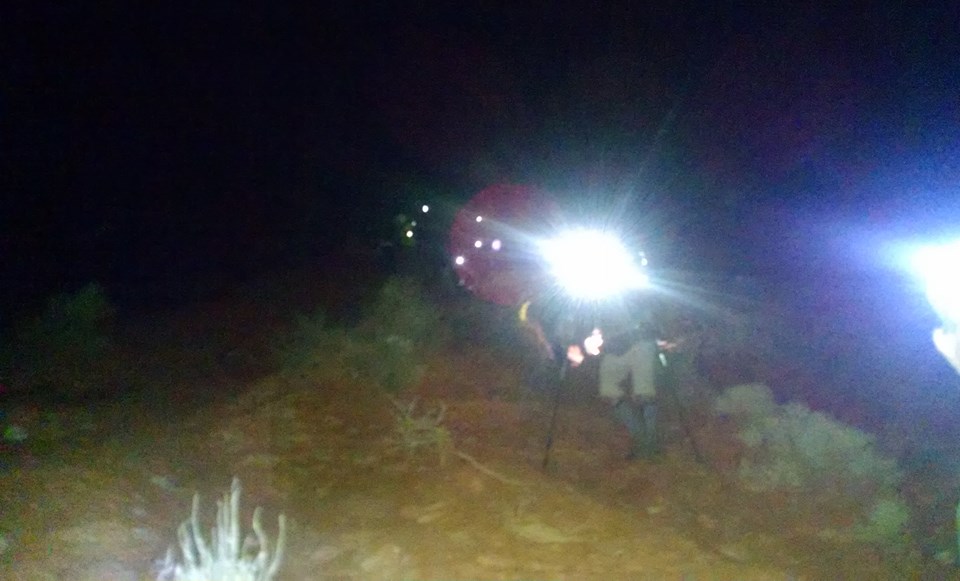
Because the hikers had only been prepared for a much shorter hike, it became dark before they were able to find their way out again. They were not equipped with flashlights or jackets, having anticipated being back well before nightfall, and they resultantly got “ledged up,” meaning they were unable to climb down from where they were, Thomas said.
“When they realized they didn’t know the way down, they were smart and called (for help),” he said.
The hikers had a cellphone and called 911 when they realized their predicament, but emergency responders hit an unusual snag after that.
When someone calls 911 from a cellphone, emergency responders are typically able to obtain GPS coordinates to help locate the person. However, the GPS coordinates obtained from this particular 911 call were inaccurate, Thomas said, and pointed responders to the middle of Ivins rather than the place where the stranded hikers actually were.
The Washington County Sheriff’s Office had previously received an email alert from the Utah Department of Public Safety’s Statewide Information & Analysis Center, informing them that an unspecified kind of testing was being performed in Tonopah, Nevada, over the weekend and possibly through Monday that could throw off GPS coordinates in certain areas. This affected the search and rescue team’s ability to accurately pinpoint, using GPS, where the hikers were.
Staying in contact with the hikers by phone, emergency responders resolved the issue by flashing their emergency lights and asking the hikers if they could see them. The hikers were able to see the lights, and they responded by shining a cellphone flashlight to signal the responders. The emergency team was then able to pinpoint where on the mountain the hikers were and eventually get to them.
A team of about 10 search and rescue volunteers was ultimately able to rescue the hikers without the need of any specialized equipment. It took just over two hours to get the hikers out.
“They were probably down off the mountain by 10 (p.m.),” Thomas said.
In addition to the search and rescue team, the Santa Clara-Ivins Police Department responded to assist on the emergency call.
The lesson to learn, Thomas said, is always be prepared before departing on a hike or other recreational excursion and take things like flashlights, jackets and water.
“It’s very easy to throw a few things into a pack,” he said.
“You need to be prepared no matter what you expect, because you just never know,” he added.
Monday’s search and rescue effort marks approximately 10 such rescue missions in January so far, Thomas said. There were only about 34 rescues total last year, he said, so 2015 is off to a very busy start.
The Washington County Search and Rescue team, which operates under the direction of the Washington County Sheriff’s Office, is comprised of unpaid volunteers who use their own equipment to assist in rescue situations. Though the team members do not get paid, the gratitude of someone who has been rescued is a satisfying reward at the end of a successful mission, Thomas said.
“We do this because we love it,” he said.
Related posts
- Search and rescue assists stranded couple on Upper Bear Valley Road
- News short: Search and rescue locate 2 women, dog ledged up in Snow Canyon Park
- SAR teams rescue man stranded on snowy back road
- County SAR makes 1st run of new year, helps couple stuck at reservoir
Email: [email protected]
Twitter: @STGnews
Copyright St. George News, SaintGeorgeUtah.com LLC, 2015, all rights reserved.
Once again, another fine job by our SAR team heros!
I just cannot get my mind around people who will believe what a map, (or GPS) says, over what their eyes tell them! The good lord gave us eyes, and he gave us all, at least a small amount of intelligence. How about using those tools, rather than depending on maps made be people who are not able to see what is actually “on the ground.” In our environment here, what may have been a perfectly good road or trail yesterday, could be totally washed away, or an impassible quagmire because of storms.
Betcha they don’t do that again, because the next misadventure may lead to a permanent retirement. How many mistakes can you find here? First, it took them hours just to find the trail? That should have been their first clue. Thought people were supposed to get wiser in their old age.
Gotta love the search and rescue teams!
Yep
Easy to forget how short the days are and how cold it gets at night on a pleasant day like Monday. Always be ready to spend the night. Red cliffs desert reserve maps show the two routes up red mountain.
HI
Well the logic of globalized self directory for directional computation based on the human factors of traversing an area of visual unawareness pertaining to the actual location has been negatively affected by the magnetic down force by which only an ionic field factor of 899.535 % of the gravitational thermo layer can biologically reinstate itself
I must commend the journalist for an article well written! I am somewhat dissapointed at Washington County SAR (Mike Thomas) at comments made concerning fault though! Preface: I’m Bo Beck, manager of The Desert Rat “local outdoor retail store”, and have recently been asked to provide “instruction of high angle rescue technique” to Washington County SAR members. Since 1996 I have provided assistance to Zion National Park as a SAR Volunteer. I have been a rock climber since 1976, taught global survival in the USAF 1975-1979, and have navigated sailboats around the world. Two years ago I wrote a hiking guidebook “Favorite hikes in and around Zion” with co-author Tanya Milligan which has sold over 8000 copies, assisted in the writing of another book authored by local Dave Nally, “Flash Floods, Falls, Death and Rescues In Zion National Park”. Mike Thomas has stated “Misinformation”? #1…the map in question if read properly, and I re-iterate “read properly”, states that the “trail” in question is a “PRIMITIVE ROUTE”. Mike, I ask you….when was the last time you looked at the BLM Arizona Strip map and decided to take your family on an afternoon casual road trip in your family sedan down to the Tuckup TH in GCNP? I bet you looked at the terrain on the map and felt that maybe high clearance or even 4wd might be a good call? What are legends on maps for? Just extraneous map filler? “PRIMITIVE ROUTE”. That raises a RED FLAG in my book! How About yours? #2….I assume that the misinformation you refer to “5 Hours Beta”, refers again to “Beta” gained at The Desert Rat? Yes……3 Weeks ago some employees and friends took a hike and traversed The Red Mountain. 5 hours is what it took us. I have traversed Red Mountain Many times with both friends and solo, and know what the terrain offers, but would NEVER mislead a first timer with “ego based beta”. As a matter of fact I generally suggest to first timers to ascend the south end of Red Mountain from Ivins to get a feel for the type of terrain to be expected, as well as gaining critical knowledge for the proper descent from the Red Mountain. Baby Steps! Now…back to the map. You are trying to get the publisher “Adventure Maps” to delete the Red Mountain Trail from the map? Why don’t you get UDOT, ADOT, and NDOT to delete I-15 “Virgin River Gorge” from maps…..You’d save many more lives and emergency services callouts as compared to deleting a single recreational route from a recreational map.
FWIW…
Bo
Listen to Bo. Most knowledgeable and macho outdoorsman in Washington County.
And PS: I will keep selling the aforementioned map, and will also contact Adventure Maps and highly suggest that they not Remove Red Mountain Trail from the map. If that get’s me fired from Washington County SAR (even before our first training together tonight) then so-be-it!
Another comment: If they were told that the hike takes 5 hours, why on earth would a person start the hike at Noon? It’s getting dark at just after 6PM , and common sense tells a person to give yourself a couple of hours buffer! Things just don’t add up. People need to take some responsibility for their own actions. Sorry to be so brutally truthful, but there it is…..laid out on the table.
Glad this story had a happy ending! Those cellphone flashlights can literally be a lifesaver. One of my favorite apps 🙂
I’ve hiked this trail before and it starts out real nice, but in a mile or so it seems to fragment with lots of off-trails and no markings. An inexperienced hiker should know better to keep going on an unknown trail. But, eh, that is how inexperienced hikers become experienced hikers.
I agree with Bo Beck 100%. It would be idiotic to blame it on the map makers or anyone but the hikers. I have done this hike only once all the way down, and it took 5 or so hours and although none of us had done it, we went into it knowing that there was no trail at certain points. We started early, knew it would probably take longer than expected. We also had headlamps, warm clothes and extra food and water just in case. The fault is on no one but the hikers for being unprepared.
And to the editor, the real headline should read “Unprepared hikers cause nighttime rescue by SAR team on Red Mountain Trail”
Just had a lengthy conversation with Mike. My bad. Apparently the hikers didn’t get their beta and map here at the Desert Rat, and the map they purchased does suggest the Red Mountain Trail is a “Trail”. Also the verbal beta they recieved suggested just 5 hours? Well…my apologies to Mike for ripping on him for suggesting that the “Hikers” recieved eroneous beta from us. I still must suggest that responsibility falls on the shoulders of the Hikers. Ultimately it IS their responsibility to keep themselves safe.
Seems like a business person would take a bit of time to dig into things a bit before running off at the mouth. I have to wonder just how much business your posts are going to cost you.
Not much to do about it now, except to learn from the experience.
Point taken! I still stand behind my opinion that people need to be responsible for their own actions. Myself included.
I completely agree with both Bo and Casey, when it comes to being responsible for your own actions! That has been one of my strongest messages, over and over on here!
The washington county rescue team is lucky to have Bo as a volunteer. Im sure mike speaking as a public p.r. dude knows this value and can shake off some slight misinformation in a public forum. 1st amendment is freedom of speech. Bo is one of the most highly respected, knowledgeable, friendly and genorous people in this town that I have the pleasure of knowing. Bo thanks for ur service and numerous hours of free time dedicated to search and resue. I know he has personaly had to resuce close friends who didnt survive. Despite the tramautic events, he still volunteers. And yes… misguided unskilled hikers involved, if the trail and info was removed more folks would get lost and stranded by hearsay. Update the trail description. Good job and thanks to those who volunteered their time.
Jamie, since I consider Bo and Mike both close friends and completely agree with everything that you said about Bo, I do however think that you need to also know who your speaking about when you are calling Mike a “public P.R dude”. Mike Thomas is just a little bit more than just a “P.R dude”. He is currently the Washington County Search and Rescue Commander and he has been volunteering his time as a member of the SAR team for 13+ years. I believe he deserves a little bit more respect than you are giving him. Oh….and a simple thank you to him as well.
Sincerely, Rob Girouard – Washington County Search and Rescue High Angle Team Captain.
I don’t know him, but I like Bo.
Exactly, people need to be responsible for their own actions. I am with Bo on this one!
Just to clarify a few things: I “assumed”, and you know what that does to you and me! I assumed that Mike refered to a map published by Adventure Maps which we here at The Desert Rat, proudly sell. The map in question used by the “temporarily disoriented hikers”, is one that was approved by HCP that shows the Redcliff Desert Reserve. It is a good map, however it shows the “Red Mountain Trail” as a “TRAIL”, and not a “primitive route”. This can be misleading. Yes….it’d be nice if “they’d” put in the legend that it is a primitive route. Yes it’d be nice if BLM at the trailhead kiosk would show that the hike is a primitive backcountry route, and that navigational skills are required. Secondly, i’d like to sincerely apologize again to Mike for assuming that he referred to The Desert Rat as the source for the “misinformation”. Just a note: When setting out on an unfamiliar hike; find and use as many resources (maps, books, trail/route descriptions, verbal beta, etc.) before setting out! Also…….get early starts! Daylight is a friend; nighttime can be a foe!
Thanks,
Bo