GRAND CANYON NATIONAL PARK – Sixty miles south of Fredonia, Arizona, down a long, rough dirt road lies a rare treat called the Toroweap Overlook in the Tuweep area of the Grand Canyon National Park. Toroweap offers stunning views of the Grand Canyon in an extremely remote and rugged location.
If you have a high-clearance vehicle, plenty of emergency gear, and a couple of like-minded friends, you may want to take a trek to Toroweap. The best part is, you can have it almost to yourself if you’re willing to brave the winter elements and make the long bumpy ride.
On a chilly Saturday morning, a small group of friends gathered for a “fun run” with a local off-road group, the Desert Roads and Trails Society. Fun runs or “expo runs” are expeditions suitable for stock four-wheel drive vehicles, not necessarily modified in any way.
Desert Roads and Trails Society, or Desert RATS for short, is a family-friendly, Utah nonprofit organization, and anyone with a four-wheel drive vehicle is welcome to join.
The group met up at a gas station in Washington on the way out of town to gas up, grab a hot beverage and catch up a little before heading out on the road.
A visit to Tuweep provides an opportunity for an uncrowded, rustic, and remote experience. However, access is challenging and demands skill at negotiating difficult roadways. Services are nonexistent: there is no water, gas, food, lodging, or phone service.
This is a remote and potentially hazardous area; warnings
- Check the weather before you go
- High-clearance vehicles are necessary
- Bring tire plugs and a portable air compressor to repair flat tires
- Make sure you have enough fuel, a full-size spare tire, jack/lift, and owner’s manual
- Tow service costs $1,000 to 2,000 and assistance is not guaranteed
- Carry extra water, plenty of gasoline, food, and warm clothing in case of emergency
Need to know
- No trailers, recreational vehicles, or vehicles over 22 feet are allowed
- Day use only; the area is open sunrise to 30 minutes past sunset
- Camping is by reservation permit only
- Fires or charcoal grills are prohibited
- No hunting or collecting
Prohibited
- All-terrain vehicles, off-road vehicles, side-by-sides, dirt bikes and all vehicles not licensed and insured for highway use; Utah vehicles require a metal license plate. Arizona requires an MC on license plate
- Total number of vehicles is limited during peak visitation periods
- Groups should have no more than four vehicles
- Pack out all trash

Access
Access the three main routes to Tuweep from Arizona Highway 389 between Fredonia, Arizona, and St. George, Utah. Allow two to three hours driving time from St. George. Bring the Bureau of Land Management’s Arizona Strip Visitor Map, and do not rely solely on your GPS unit. Muddy conditions exist during summer monsoons and from winter precipitation.
Sunshine Route: County Road No. 109, the most reliable route, leaves Arizona Highway 389 eight miles west of Fredonia or 6 miles east of Pipe Spring National Monument. This 61-mile road features sharp rocks, washboarding and dust. Please do not stop on tribal land when traveling this route.
Clayhole Route: County Road No. 5 leaves Arizona Highway 389 at Colorado City, Arizona. It is 56 miles long and impassable when wet.
Main Street Route: BLM Road No. 1069 and County Road No. 5 from St. George is 90 miles long. This scenic route is impassable in winter due to snow and mud.
Tuweep Campground
- Nine small campsites are available for one to six people with a maximum of two vehicles, including motorcycles. One large group campsite serves seven to 11 people with a maximum of four vehicles, including motorcycles.
- One campsite allowed per group traveling or congregating together; groups may not occupy multiple campsites.
- Picnic tables and composting toilets provided. No water available. Store all food and garbage in a vehicle. No fires or charcoal grills.
Tuweep hiking trails
- Tuweep’s hiking trails are marked with cairns (piles of rocks). Shade is scarce and water nonexistent. Walk only on trails, roads, and washes. Each footstep off-trail may destroy fragile biological soil crusts and damage native plants. All trails are closed to pets, bicycles, and vehicles.
- Tuckup Trail: Experience Tuweep’s unique geology on this six-mile (10K) roundtrip trail. There are two access points: the first is signed before arriving at Tuweep Campground and the second leaves from Campsite 10.
- Saddle Horse Loop Trail: This 45-minute loop offers spectacular views of the Colorado River. Access the trail along the road between Toroweap Overlook and Tuweep Campground or from a trailhead near Campsite 5.
- Whitmore Trail: Located at Whitmore Overlook, a two-and-a-half hour drive west of Tuweep, this moderate 4 mile (6.5 km) roundtrip trail takes you down to the Colorado River. Access Whitmore Overlook from the Main Street Route, high clearance vehicle needed.
Click on photo to enlarge it, then use your left-right arrow keys to cycle through the gallery.

Just outside Fredonia, Arizona, on the road to the Toroweap Overlook in the Tuweep area of the Grand Canyon National Park, Arizona, Jan. 3, 2015 | Photo by Julie Applegate, St. George News

Old road grader in the Tuweep area of the Grand Canyon National Park, Arizona, Jan. 3, 2015 | Photo by Julie Applegate, St. George News

Old wooden building on the road to the Toroweap Overlook in the Tuweep area of the Grand Canyon National Park, Arizona, Jan. 3, 2015 | Photo by Julie Applegate, St. George News

Getting close to the Toroweap Overlook in the Tuweep area of the Grand Canyon National Park, Arizona, Jan. 3, 2015 | Photo by Julie Applegate, St. George News

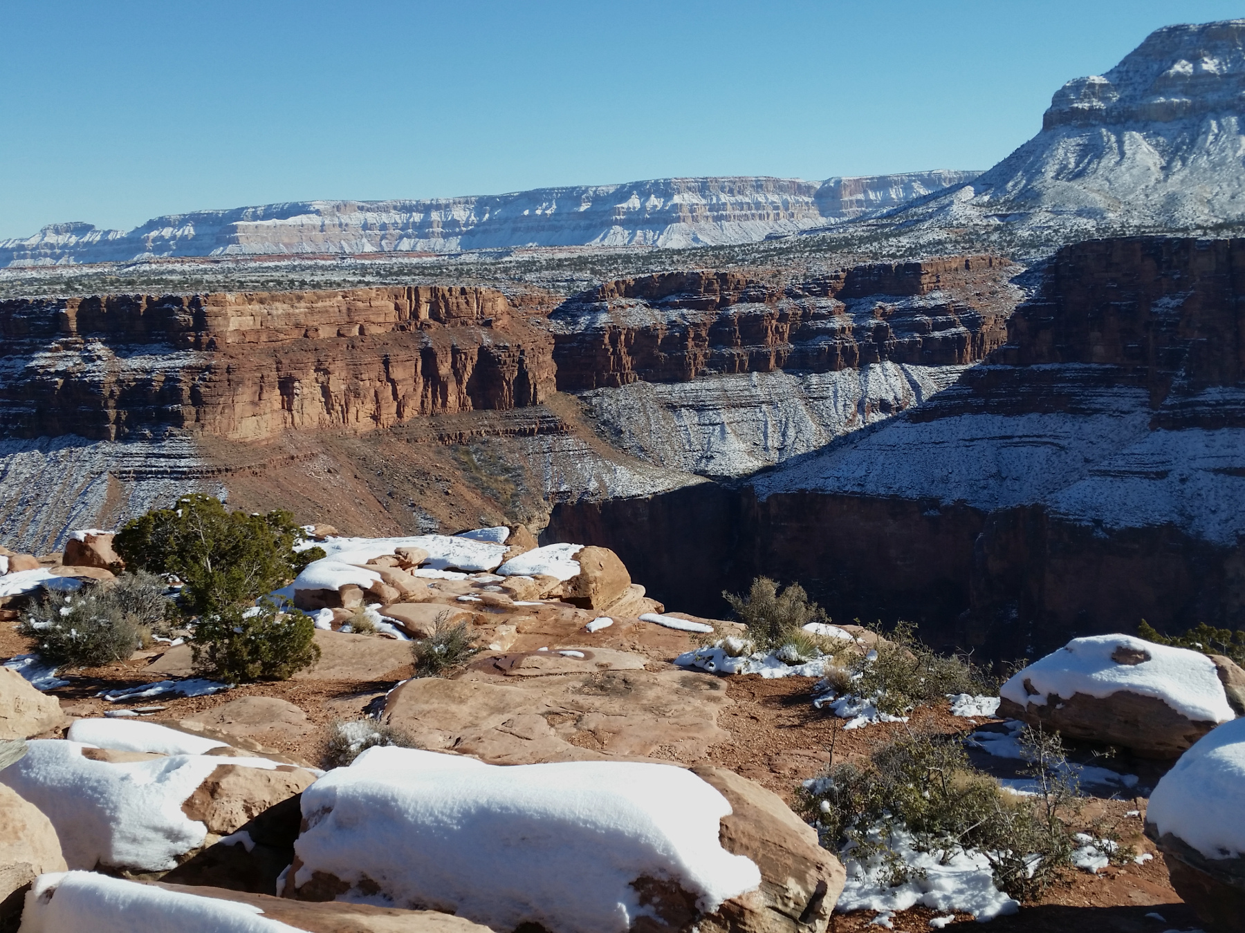
Cliffs at the Toroweap Overlook in the Tuweep area of the Grand Canyon National Park, Arizona, Jan. 3, 2015 | Photo by Julie Applegate, St. George News

Looking downstream towards Lava Falls on the Colorado River, from the Toroweap Overlook in the Tuweep area of the Grand Canyon National Park, Arizona, Jan. 3, 2015 | Photo by Julie Applegate, St. George News

Entrance to the Toroweap Overlook in the Tuweep area of the Grand Canyon National Park, Arizona, Jan. 3, 2015 | Photo by Julie Applegate, St. George News

Looking east from the Toroweap Overlook in the Tuweep area of the Grand Canyon National Park, Arizona, Jan. 3, 2015 | Photo by Julie Applegate, St. George News

Toroweap Overlook in the Tuweep area of the Grand Canyon National Park, Arizona, Jan. 3, 2015 | Photo by Julie Applegate, St. George News

View of the Colorado River from the Toroweap Overlook in the Grand Canyon National Park, Arizona, Jan. 3, 2015 | Photo by Julie Applegate, St. George News

View of the Colorado River from the Toroweap Overlook in the Tuweep area of the Grand Canyon National Park, Arizona, Jan. 3, 2015 | Photo by Julie Applegate, St. George News

Entry to the Toroweap Overlook in the Tuweep area of the Grand Canyon National Park, Arizona, Jan. 3, 2015 | Photo by Julie Applegate, St. George News

Toroweap in the Tuweep area of the Grand Canyon National Park, Arizona, Jan. 3, 2015 | Photo by Julie Applegate, St. George News

Toroweap in the Tuweep area of the Grand Canyon National Park, Arizona, Jan. 3, 2015 | Photo by Julie Applegate, St. George News
Resources
- To join the Desert Roads and Trails Society, visit their forum or Facebook page.
- National Park Service Tuweep Web page
Related posts
- Desert RATS Sand Mountain cleanup took desert by storm; STGnews Photo Gallery
- Explore: Make 2015 a ‘trailtastic’ year; where to run, hike and ride in the new year
- Explore: Earth’s fiery history right beneath your feet; Cinder Cone Trail
- Explore: Scenic access to ancient rock writing; Santa Clara River Reserve
Email: [email protected]
Twitter: @STGnews
Copyright St. George News, SaintGeorgeUtah.com LLC, 2015, all rights reserved.
Awesome trip. Have done this trip numerous times, and each time I find something new. The trip over Mt. Trumbull is also amazing. That being said, the restrictions list is sure starting to mount.
Take two full size spares.
Great article and photos, Julie. It was a really fun day and I’m glad we went down there.
What a well-done article. Haven’t been to Tuweep and Toroweep for over a decade and your photos gave a most enjoyable memory trek. Thanks much.