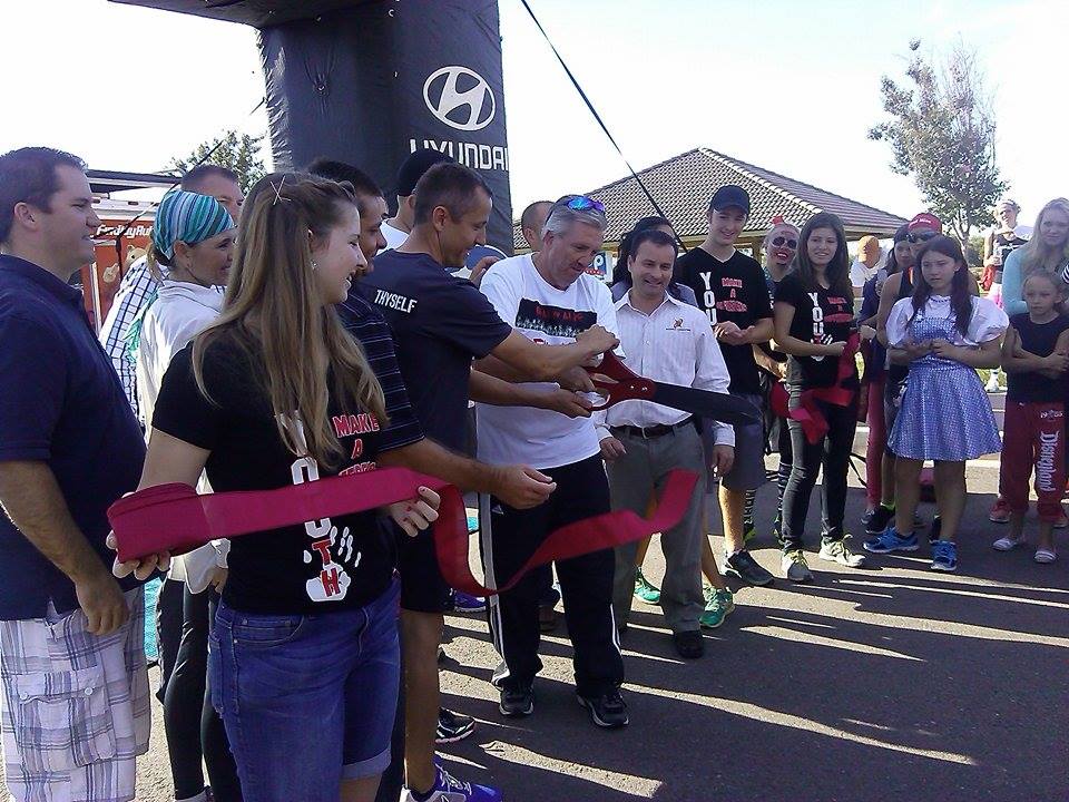
WASHINGTON CITY — Following the Dead or Alive 5K and 10K, some 100 people comprised of families, runners and a few super heroes and goblins, joined at the Sullivan Virgin River Soccer Park, located at 965 S. Washington Fields Dr. in Washington City, Saturday morning to celebrate the official opening of the Virgin River Boardwalk Trail.
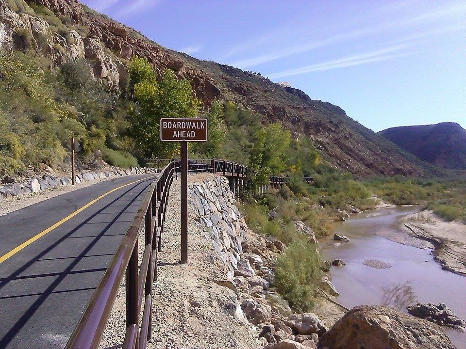
After about 8 months of construction, an idea — conceptualized around 5 years ago — came to fruition; carving a 2-mile asphalt trail with 600 feet of a wooden boardwalk that coasts along the Virgin River, crosses three designated wetlands and winds east where it connects to the Grape Vine Trail and the Cottonwood Trail on the east side and continues as far west as Man O War Bridge trailhead in Bloomington on the west side, said Director of Parks and Leisure Service Barry Blake.
The Virgin River Boardwalk trail facilitates the activities akin to other paved trails in Southern Utah such as cycling and running; though, it also benefits the community because it provides access along the Virgin River for emergency vehicles in the case of a wilfire, Blake said. The boardwalk spans 10 feet in width, 600 feet in length and has a 10,000 weight capacity.
“This was a vital piece to connect with the three rivers trail system,” Blake said. “This gets us to Sunrise Valley.”
This $1.2 million project was a collaborative effort among Washington City, Alliance Consulting and J.P. Excavating. Before the project got started; however, there were quite a few obstacles to complete such as obtaining permitting through Fish and Wildlife, Army Corps engineers and Bureau of Land Management, said Alliance Project Engineer Mike Bradshaw.
One of the most difficult parts of constructing this trail was figuring out how to bank in the steep slope that rises from the north side of the trail, Bradshaw said. In order to counter the steep slope, the engineers designed an elevated boardwalk secured with cement pillars that stem about 14 feet below on the downside of the slope and 2 feet below on the uphill.
“When we first started, we probably walked this stretch 20 times. The tamarisk and shrubbery were so thick we had to chop our way through with a machete,” Bradshaw said. “When you get out there, when it’s quiet, you can hear the water trickling through the wetlands.”
This trail adds another “awe-factor” not just for the community but Southern Utah as a whole, Washington City Mayor Ken Neilson said.
“When I was a kid we never had this kind of access to the river right here unless you had a horse or were hunting,” Neilson said. “Our end goal is to connect trails from SunRiver to Zion National Park.”
Click on photo to enlarge it, then use your left-right arrow keys to cycle through the gallery.

Washington City Mayor Ken Neilson snips the ribbon marking the official grand opening of the Virgin River Boardwalk Trail, 965 S. Washington Fields Drive, Washington, Utah, Oct. 11, 2014 | Photo by Aspen Stoddard, St. George News

A crowd gathers for the official grand opening of the Virgin River Boardwalk Trail, 965 S. Washington Fields Drive, Washington, Utah, Oct. 11, 2014 | Photo by Aspen Stoddard, St. George News

Washington City Mayor Ken Neilson gives a thumbs up at the official grand opening of the Virgin River Boardwalk Trail, 965 S. Washington Fields Drive, Washington, Utah, Oct. 11, 2014 | Photo by Aspen Stoddard, St. George News

At the official grand opening of the Virgin River Boardwalk Trail, 965 S. Washington Fields Drive, Washington, Utah, Oct. 11, 2014 | Photo by Aspen Stoddard, St. George News

East side of the boardwalk on the Virgin River Boardwalk Trail, 965 S. Washington Fields Drive, Washington, Utah, Oct. 11, 2014 | Photo by Aspen Stoddard, St. George News

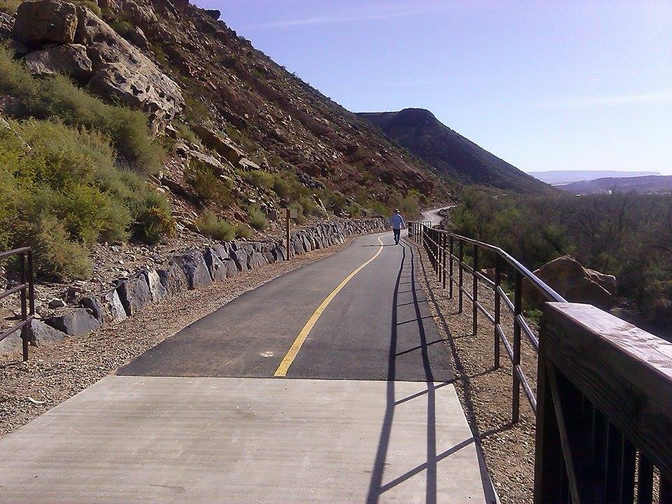
View from the boardwalk of the Virgin River Boardwalk Trail, 965 S. Washington Fields Drive, Washington, Utah, Oct. 11, 2014 | Photo by Aspen Stoddard, St. George News

View from the boardwalk at the Virgin River Boardwalk Trail, 965 S. Washington Fields Drive, Washington, Utah, Oct. 11, 2014 | Photo by Aspen Stoddard, St. George News

At the official grand opening of the Virgin River Boardwalk Trail, 965 S. Washington Fields Drive, Washington, Utah, Oct. 11, 2014 | Photo by Aspen Stoddard, St. George News

View of the Virgin River Boardwalk Trail, 965 S. Washington Fields Drive, Washington, Utah, Oct. 11, 2014 | Photo by Aspen Stoddard, St. George News
Related posts
- Nearly 100-year-old trails get major rehab, Zion National Park
- Unveiling the labyrinth: Amazing race to the altar
- Dancing in the drizzle; R’Oktoberfest rings in winter season
Email: [email protected]
Twitter: @STGnews
Copyright St. George News, SaintGeorgeUtah.com LLC, 2014, all rights reserved.
This is the sort of development we need and, money well spent. Well done!
Is there a map locating the area this covers, and where it connects?
I second that! Maybe I’ll just have to go ride it and do a GPS trace and put it on OSM. Who knows when they’ll have a map of it on their website…
Yes a map would be real nice!
I rode it this afternoon (Sat. 10/11). What a gorgeous trail! You can get a decent view of the trail portion about a mile east of Sullivan Park at Google maps (I’m looking at their Zoom level where 1000 yards is about an inch, displayed in lower right of map page). The new trail (first mile not shown) basically follows the Virgin River to Grapevine Pass Wash, about a mile in, where you can leave the Virgin River Boardwalk Trail and head north to Cottonwood Wash (both names should display at the correct Zoom level). From Cottonwood Wash you can take the left fork and head north to a connection with E. Telegraph St, just opposite the Washington Pkwy, or follow the main trail that turns east and deadends west of Landfill Rd. Both of these sections have interesting uphills. If you stay on the Virgin River Boardwalk Trail, it’ll continue another mile east from Grapevine Pass Wash and end in gravel before getting to the abandoned bridge at S Country Way.
Will mike shaw get to drive his ford trucks on the trail?
I just went ahead and mapped it on the OSM. I’d prefer the cyclemap style, but that one doesn’t get updated as often, so you might not see it on there for a while.
The bridge section was kind of a guess, since I didn’t think to mark where it began and ended when I was riding it.
Thanks Randy. Very nicely done!