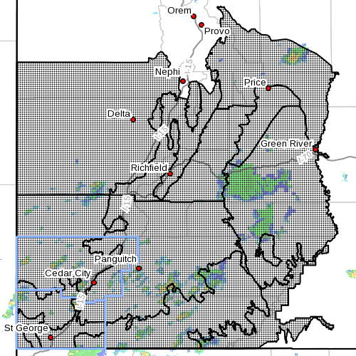
SOUTHERN UTAH — The National Weather Service has issued a “Flash Flood Watch” for much of central and southern Utah, in effect Sunday until 6 p.m. Tuesday.
Conditions
Scattered showers and thunderstorms are capable of producing heavy rainfall and will bring an isolated flash flood threat to specifically Southern Utah Sunday afternoon.
Tropical moisture associated with Hurricane Norbert will then bring a significant moisture surge into southern and central Utah Sunday evening through Tuesday. A prolonged period of moderate to heavy rainfall and embedded thunderstorms is expected to produce widespread amounts of 1-3 inches of rain with some areas from Utah’s Dixie northeast to the central Interstate 70 corridor possibly seeing up to 5 inches of rain through this time period.
Affected areas
Wasatch Plateau / Book Cliffs, Castle Country, San Rafael Swell, Sanpete/Sevier valleys, Southwest Utah, Utah’s Dixie and Zion National Park, south-central Utah, Glen Canyon Recreation Area / Lake Powell, central mountains, southern mountains, including the cities of Scofield, Price, Castle Dale, Emery, Green River, Hanksville, Manti, Richfield, Beaver, Cedar City, Milford, St. George, Kanab, Escalante, Bullfrog, Cove Fort, Koosharem, Fish Lake, Loa, Panguitch and Bryce Canyon.
Most threatened
Flash flooding is most likely in slot canyons, normally dry washes and burn scars. Main stem river flooding of urban centers will become possible by Monday. Most all back country roads are likely to become impassable across central and Southern Utah.
Precautionary, preparedness actions
A flash flood watch means that conditions may develop that lead to flash flooding. Flash flooding is a very dangerous situation. Readers are advised to monitor later forecasts and be prepared to take action should flash flood warnings be issued.
Related posts
- St. George Library floods for 3rd time after heavy rains
- News LIVE: Heavy rains cause flooding, structure failures, multiple car accidents; UPDATED 11 PM, STGnews Photo Gallery
- Flash flood warning for LaVerkin Creek, watch for Washington, Kane, Garfield counties
Email: [email protected]
Twitter: @STGnews
Copyright St. George News, SaintGeorgeUtah.com LLC, 2014, all rights reserved.
The real bobber will blame the rain on the religious views of the local residents
Will the downtown library flood for the 5th time? Can we please put some sand bags down just in case?
They built a new wall so do some research before shooting off your mouth
I’m sure that basement will flood for a 4th, 5th, and 6th time. We’ve obviously got some real geniuses in charge of the place.
If we just left it full of water we could add some koi fish and maybe even an alligator. Oh what fun! Who needs books!
Who want to bet on how many homes will flood out and the owners of those homes will blame to locol city governments for having a poor drainage system.
Bobber will blame the bishop or something crazy. The dude has issues.
Gosh, why don’t you comment on the news rather than other people? The rate this storm is going, NO ONE will be flooded out in this region.
5 inches?! I don’t think I’ve ever in my life seen that much rain forecast for Utah!!
If we do get the rain in Washington city I wonder what mike shaws excuse will be this time
Mike Shaw will say the same drivel….it worked until it didn’t….it works if it stays dry…blah…blah…blah.
HOW LONG CAN YOU TREAD WATER? Bwaaaaaaaahaaaaaaaaaaa.
Bring on the rain! I love these slow moving thunder dumpers that drop enough water to cover the sidewalks from one side of the street to the other and create whitewater down the middle of the street.
I know I’ll be okay because I did research on my house before I bought it. Went back 50 years and no flooding.
Sounds like you’re good to go, just as long as fifty years of neighborhood growth and development haven’t changed local drainage patterns to your detriment…
Maybe mike shaw is riding in his new ford city truck hoping it sinks so he can get another new one