UPDATED 4:20 P.M.
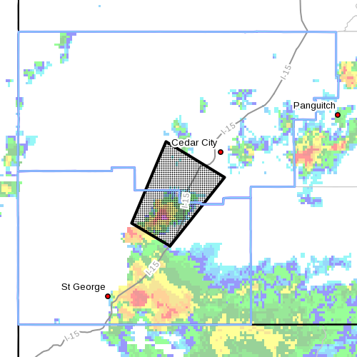
SOUTHERN UTAH – At 4:12 p.m. the National Weather Service issued a severe thunderstorm warning for northeastern Washington County and south-central Iron County, in effect until 4:45 p.m. Doppler Radar indicated a severe thunderstorm capable of producing quarter-size hail and damaging winds in excess of 60 mph. This storm has located over New Harmony, or 20 miles southwest of Cedar City, moving northeast at 20 mph.
Affected areas
New Harmony, anarraville, Kolob Canyon and Pintura
Precautionary/Preparedness actions
Severe thunderstorms produce damaging winds, destructive hail, deadly lightning and very heavy rain.
For your protection, move to an interior room on the lowest floor of your home or business.
Heavy rains flood roads quickly so do not drive into areas where water covers the road.
Torrential rainfall is also occurring with this storm and may lead to flash flooding.
Do not drive your vehicle through flooded roadways.
EARLIER ADVISORY FOR WASHINGTON COUNTY – The National Weather Service has issued a flash flood warning for south-central Washington County in effect 3:27-9 p.m. Monday.

At 3:27 p.m. Doppler Radar indicated a thunderstorm producing heavy rain over the Fort Pearce Wash n Arizona. Radar rainfall amounts of over 2 inches in an hour’s time has fallen in this drainage. The Fort Pearce Wash flows into Utah’s Washington County and then into the southern end of St. George from Arizona.
At 3:30 p.m. Doppler Radar indicated a strong thunderstorm 11 miles south of Hurricane, or 16 miles east of St. George, moving northeast at 15 mph.
Penny to nickle-sized hail and winds of 40-55 mph will be possible.
Additional drainages in the Virgin Gorge are also anticipated to be impacted.
This waterway flows near Interstate 15 and then back into Arizona.
Affected areas
St. George, Washington, Hurricane, Santa Clara, LaVerkin, Ivins, Hildale, Toquerville, Leeds, Virgin, Springdale, Rockville and Bloomington.
Precautionary / Preparedness actions:
Move to higher ground now. Act quickly to protect your life.
“Get everybody. Don’t try to save personal belongings or vehicles,” Deputy Darrell Cashin, Search and Rescue Commander with the Washington County Sheriff’s Office, said as a watchword for those confronting a flash flood.
A flash flood can happen with little or no warning and individuals may only have seconds to act before it’s too late.
After getting to higher ground, it is important for individuals to remain where they are until either the waters have receded to a safe depth or rescue has arrived.
When you think it’s safe, wait an hour longer
“Let it recede, let it pass,” Cashin said. “When you think it’s safe, wait an hour longer.”
Turn around, don’t drown
Related posts
- What to do before, during, after a flash flood
- I can’t believe I survived; video of flash flood crashing down on canyoneers
- Flash Flooding in Washington City
- Highway through Zion Park closed due to flooding
- Angell Heights Estates in Hurricane threatened by heavy rainfall, flooding; STGnews Photo Gallery
- Thunderstorms trigger flooding near Panguitch
- Flash flooding Washington County; STGnews Photo Gallery
- Record rainfall in Cedar City results in ‘massive flooding’ throughout city; STGnews Photo Gallery
- Flash Flood Watch for Southern Utah; STGnews Videocast of Washington City urban flooding
- Flash flooding meets River Road near Southern Parkway; Videocast, STGnews photo gallery
Email: [email protected]
Twitter: @JoyceKuzmanic
Copyright St. George News, SaintGeorgeUtah.com LLC, 2014, all rights reserved.
20140818.1837 Fort Pearce Wash expected to rise by eight feet in next one hour. Trails being closed. Golf course and auto row expected to see some flooding. Should be interesting.
We have a reporter at Tonaquint and Southgate – Hilton Drive – bone dry at 7:25 p.m. That doesn’t mean a flood won’t flash though.
Thanks, jmb
JOYCE
EIC
How come it never rains on S.Valley View and Indian Hills?
Reminding me of some of the storms we got back in Georgia. I admit it, I was sitting on the sofa and then bam it scared the crap out of me. Almost like tornado weather. Its the worst I have seen since we moved here.
Heck ya Bill I agree! I’m a Georgia boy too! I was up early this morning saying the same thing to The Wife.