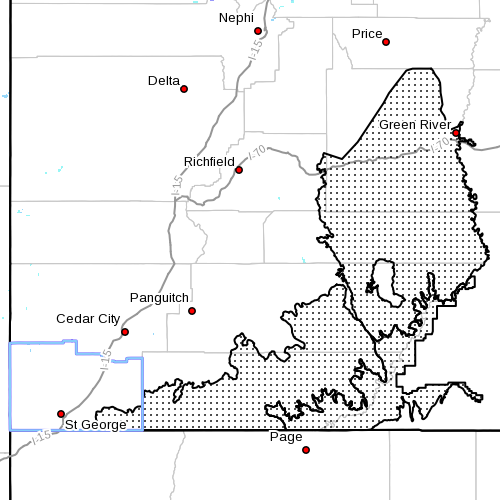
SOUTHERN UTAH – The National Weather Service has issued a “Wind Advisory” in effect from 9:29 a.m. to 10 p.m. today in south central and southeast Utah, including Lake Powell.
Areas Affected
San Rafael Swell, south central Utah, Glen Canyon Recreation Area/ Lake Powell, including the cities of Green River, Hanksville, Kanab, Escalante and Bullfrog.
Timing
Winds will continue to increase through the morning. They will remain strong through the afternoon hours before decreasing this evening.
Impacts
Strong winds will make travel difficult especially for high profile vehicles along east to west oriented routes, including but not limited, to Interstate 70 across eastern Utah, and Highway 89 across far southern Utah. In addition, these winds could result in choppy waters and dangerous boating conditions on Lake Powell.
Winds
South winds 25-35 mph with gusts up to 50 mph.
Precautionary/Preparedness actions
A “Wind Advisory” means that sustained wind speeds of at least 31 mph or gusts of 45 mph are expected.
Motorists in the advisory area should be prepared for sudden gusty crosswinds which can make driving difficult.
Related posts
- Wind advisory: Crosswinds may cause travel difficulties
- Strong winds and gusts incoming; motorist and boater cautions
- Wind advisory, particularity to southern Washington County
Email: [email protected]
Twitter: @STGnews
Copyright St. George News, SaintGeorgeUtah.com LLC, 2013, all rights reserved.
Sexy author/editor, just saying 😉