UPDATED: 5:15 pm. to include Kane County.
SOUTHERN UTAH – The National Weather Service has issued a “Flash Flood Warning” for east central Washington County this afternoon, in effect until 5:30 p.m, and for east central Kane County until 9:15 p.m.
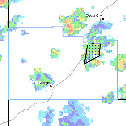
Conditions – At 2:30 p.m., the NWS Doppler Radar indicated heavy rain from a thunderstorm near the Iron and Washington County line immediately northeast of Zion National Park.
Flood waters will move primarily through the LaVerkin Creek drainage in the north end of Zion National Park. Taylor Creek may also be impacted by flash flooding.

At 4:30 p.m. the Doppler Radio indicated heavy rain from a nearly stationary thunderstorm over the affected area in east central Kane County.
Timing – Warning in effect through this evening in Washington County, and until 9:15 p.m. in Kane County.
Affected areas – In Washington County: Utah’s Dixie and Zion National Park, southwest and south central Utah, the southern mountains, and Glen Canyon Recreation Area, Lake Powell.
In Kane County: The eastern portion of the Grand Staircase Escalante National Manument. Drainages that work south into Croton Canyon and then into Lake Powell at Last Chance Bay are most likely to experience flash flooding through the middle of this evening.
Most threatened – Flash flood prone areas include slot canyons and slickrock areas, normally-dry washes, and urban areas.
Earlier “Flash Flood Watch” – The National Weather Service issued a Flash Flood Watch earlier today, still in effect for Utah’s Dixie and Zion National Park, southwest and south central Utah, the southern mountains, and Glen Canyon Recreation Area, Lake Powell. See particulars here.
Precautionary and preparedness actions – The National Oceanic and Atmospheric Association and the National Weather Service offer safety rules for flash flooding:
- Conditions may develop that lead to flash flooding. Flash flooding is a very dangerous situation.
- Flash flood waves, moving at incredible speeds, can roll boulders, tear out trees, destroy buildings and bridges, and scour out new channels. Killing walls of water can reach heights of 10 to 20 feet. You will not always have warning that these deadly, sudden floods are coming. When a flash flood warning is issued for your area or the moment you first realize that a flash flood is imminent, act quickly to save yourself. You may have only seconds.
- Most flood deaths occur in automobiles. Do not drive your vehicle into areas where the water covers the roadway. Flood waters are usually deeper than they appear. The road bed may not be intact under the water. Just one foot of flowing water is powerful enough to sweep vehicles off the road. If the vehicle stalls, abandon it immediately and seek higher ground. Rapidly rising water may engulf the vehicle and its occupants and sweep them away. Case in point: In July 2013 a tour bus in Arizona tipped over and got swept nearly one-half mile down an otherwise dry wash.
- Do not hike rivers and especially slot canyons while flash flood warnings are in place.
- Do not hike alone and always tell someone where you and your buddy and others are going.
- Get out of areas subject to flooding. This includes dips, low spots, canyons, washes, et cetera.
- Avoid already flooded and high velocity flow areas. Do not try to cross a flowing stream on foot where water is above your knees.
- Be especially cautious at night when it is harder to recognize flood dangers.
- Do not camp or park your vehicle along streams and washes, particularly during threatening conditions.
- During any flood emergency, stay tuned to your NOAA weather radio, commercial radio, or television, follow St. George News at STGnews.com and St. George News Facebook for weather alerts and updates relevant to Southern Utah. Information from the national weather service and disaster and emergency services may save your life.
Turn around, don’t drown.
Related posts – Storm, flash flooding
- Flood victims blame city for neglect
- Charges filed in tour bus accident
- Tour bus gets swept down wash after heavy rains
- UPDATED: Summer storm floods Coral Canyon homes; STGnews Videocast
- Flash flooding meets River Road near Southern Parkway; Videocast, STGnews photo gallery
Email: [email protected]
Twitter: @JoyceKuzmanic
Copyright St. George News, SaintGeorgeUtah.com LLC, 2013, all rights reserved.