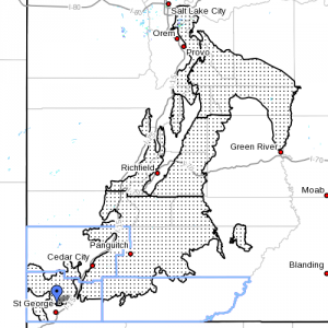
UTAH – This morning’s winter weather forecast, while still in effect, is developing into a weather “watch” for certain mountain areas listed below, in effect from Tuesday evening through Thursday morning

• Affected area: Wasatch Mountains south o f Interstate 80, Wasatch Plateau/Book Cliffs, Central Mountains, Southern Mountains, including the cities of Alta, Brighton, Scofield, Cove Fort, Koosharem, Fish Lake, Loa, Panguitch and Bryce Canyon.
• Snow accumulations: There will be 1-2 feet with 3-7 inches in the southern mountain valleys.
• Timing: Snow showers will develop Tuesday evening becoming heavy at times, first for the southern and central mountains Tuesday night through Wednesday. Snow rates will be highest for the southern Wasatch Mountains Wednesday afternoon into Thursday morning. Snow showers will taper off Thursday.
• Impacts: Mountain routes will become snow covered Tuesday night. Expect winter driving conditions to persist through Thursday morning.
• Precautionary/preparedness actions: A winter storm watch means there is a potential for a significant snow.
Related post
Triple storm series forecast for Utah, travel cautions
Resources
Vehicle Preparation and Safety Precautions for Winter Weather
For winter road conditions from the Utah Department of Transportation:
Visit UDOT’s Road Weather Alerts / Obtain UDOT’s smartphone travel app.
Email: [email protected]
Twitter: @STGnews
Email: [email protected]
Twitter: @STGnews