ST. GEORGE — The National Weather Service has issued a hazardous weather outlook for the next seven days for the western two-thirds of Utah and southwest Wyoming.
A cold front is expected to bring snow to portions of the forecast area as early as Wednesday, with more possible through the holiday weekend.
Affected areas
Local areas expected to be impacted by this hazardous weather outlook include southwest and south-central Utah, Utah’s Dixie, Zion National Park, Glen Canyon Recreation Area/Lake Powell and southern mountains.
Statewide areas include Cache Valley/Utah portion, northern Wasatch Front, Salt Lake and Tooele valleys, southern Wasatch Front, Great Salt Lake Desert and mountains, Wasatch Mountain valleys, Wasatch mountains I-80 North, Wasatch mountains south of I-80, Western Uinta mountains, Wasatch Plateau/Book Cliffs, Western Uinta Basin, Castle Country, San Rafael Swell, Sanpete/Sevier valleys, west-central Utah and southwest Wyoming.
Tuesday
Benign weather expected.
Wednesday through Monday
The cold storm system is expected to arrive over northwest Utah early Wednesday, then track southeast across the outlook area through Thursday. The leading cold front will sweep southeast across the area Wednesday through Wednesday night.
A brief period of heavy snow is anticipated along and behind the front, followed by areas of snow confined mainly to the higher terrain and along the I-15 and I-70 corridors in central and southwest Utah.
This storm is forecast to linger across southeast Utah Thursday, leading to the potential for a prolonged and significant snowfall event across the central and southern mountains and along the I-15 and I-70 corridors over central and southwest Utah. Much colder temperatures will trail this front and will remain over the outlook area through the end of the week.
A second very cold storm system out of northern Canada is expected to move south and across the region this weekend, which could generate areas of light snow and very cold temperatures across the outlook area through the holiday weekend.
Prepare and take caution
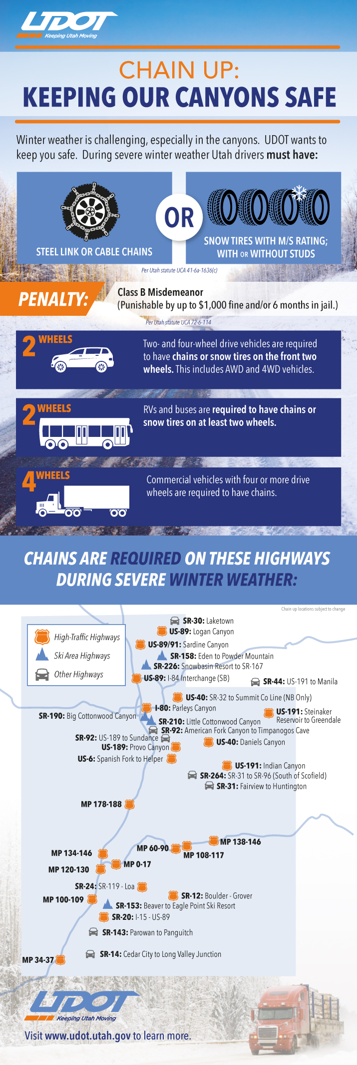
Utah law requires vehicles to have either steel link or cable chains or snow tires when driving roads in winter conditions October through March. Utah Department of Transportation’s infographic with particulars follows below.
Now is a good time to stock vehicles with a number of items that can make the difference between death and survival in the event of getting stuck in the snow. See St. George News checklist, previously published, here: Stocking your vehicle for winter; what to do in case of emergency, checklist.
Download this printable PDF: Vehicle Preparation and Safety Precautions for Winter Weather – this is a project the whole family could participate in – make it a scavenger hunt with potentially lifesaving benefits.
Spotter information statement
Weather spotters are encouraged to report significant weather conditions to the National Weather Service according to standard operating procedures.
Resources
Email: [email protected]
Twitter: @STGnews