ST. GEORGE — High winds and gusts of up to 50 mph are expected Thursday evening through Friday in parts of Utah as far south as Cedar City.
The National Weather Service in Salt Lake City issued a wind advisory forecasting southerly winds of 25 to 35 mph with gusts up to 50 mph in the western portion of the state.
Affected area
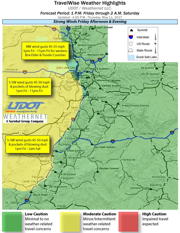
Affected areas include Salt Lake and Tooele Valleys, west central Utah and Southwest Utah, including the cities of Salt Lake City, Tooele, Delta, Fillmore, Beaver, Cedar City and Milford.
Timing
Winds will increase in some areas Thursday night and then become strong by late Friday morning. Winds will peak Friday afternoon into early evening before diminishing around sunset.
Impacts
Strong crosswinds may affect travel on Interstate 80, Highway 50 and State Routes 21 and 56, especially for high profile vehicles and those towing trailers. Visibilities may also be reduced in areas of blowing dust. Wind sensitive operations may be impacted.
Below are the primary routes these stronger crosswinds are expected to impact during the forecast period:
- I-80, Nevada to the Great Saltair.
- I-84, Idaho border to Howell.
- I-70, near Cove Fort.
- US-6, Nevada border to Santaquin.
- US-50, Delta to Holden.
- SR-21, Nevada border to Beaver.
- SR-56, Nevada border to Cedar City.
Precautions
Motorists in the advisory area should be prepared for sudden gusty cross winds which can make driving difficult.
The strong winds will also create dangerous boating conditions on area lakes. These winds will create very choppy water and generate waves which could capsize or swamp small craft.
Email: [email protected]
Twitter: @STGnews
Copyright St. George News, SaintGeorgeUtah.com LLC, 2017, all rights reserved.