ST. GEORGE — The National Weather Service has issued a hazardous weather outlook for the western two-thirds of Utah and southwest Wyoming.
The outlook forecasts hazardous weather events from Sunday night through Friday, including low temperatures and snowstorms.
Affected areas
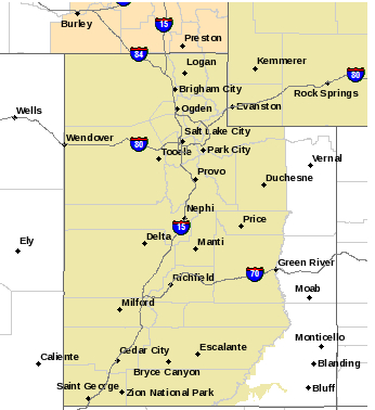
Regionally, areas expected to be impacted include southwest Utah, Utah’s Dixie and Zion National Park, south-central Utah, Glen Canyon Recreation Area-Lake Powell and southern mountains.
Other portions of the state affected include Cache Valley, northern Wasatch Front, Salt Lake and Tooele valleys, southern Wasatch Front, Great Salt Lake Desert and mountains, Wasatch Mountain valleys, Wasatch Mountains near Interstate 80 North, Wasatch Mountains south of I-80, western Uinta Mountains, Wasatch Plateau-Book Cliffs, Western Uinta Basin, Castle Country, San Rafael Swell, Sanpete-Sevier valleys, west-central Utah, central mountains and southwest Wyoming.
Timeline
A very cold air mass will remain over the area through Sunday night. Temperatures as low as 18 below zero in Manti were recorded Sunday morning.
The next storm system will cross the area late Tuesday afternoon into early Wednesday morning and bring light accumulating snow to northern and central portions of the state.
Another storm system is expected to impact the outlook area late Thursday into Friday.
Road conditions
The Utah Department of Transportation’s traffic advisory anticipates moderately severe conditions for SR 14 between Cedar City and Highway 89, SR 20 between Interstate 15 and Highway 89 and SR 12 between Highway 89 and SR 24. Highly severe conditions are anticipated for SR 143 between Parowan and Panguitch. UDOT urges caution and preparedness on these roads.
Resources
Email: [email protected]
Twitter: @STGnews
Copyright St. George News, SaintGeorgeUtah.com LLC, 2016, all rights reserved.
This is a great article to let people know what is going on. be safe out there folks and slow down and give yourself some extra time to get to your destination. and be there to enjoy the jubilant festivities of the holiday season and celebrations with your friends and loved ones.