UPDATE Jan. 28, 2017 2 p.m. Bureau of Land Management (BLM) fire managers are anticipating favorable weather conditions for pile burning on BLM-administered lands along the Muddy River, approximately 5.5 miles northwest of Moapa. The prescribed fire is anticipated to commence January 30. Previously set dates did not meet safe conditions for this prescribed fire.
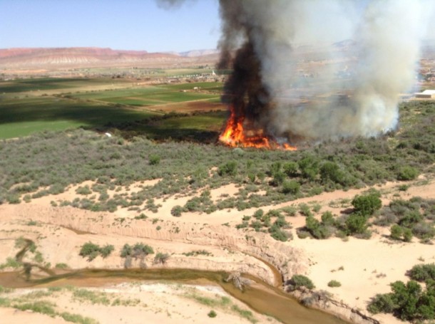
The prescribed fire is planned in an approximately 20-acre area where invasive tamarisk has been thinned and piled. The thinning and prescribed fire are part of an ongoing effort by the BLM in Southern Nevada to restore healthy, diverse and resilient ecosystems to conditions that minimize the potential for uncharacteristically intense fires.
Twenty firefighters will be assisting with the prescribed fire, including two who will work overnight to ensure the prescribed fire is confined to the piled tamarisk.
ST. GEORGE — The Bureau of Land Management’s southern Nevada district has announced a public meeting that will be held Tuesday to discuss a prescribed fire plan for certain areas along the Muddy River aiming to remove piles of invasive tamarisk. The meeting will take place from 7-8:30 p.m. in the Marley P. Robinson Justice Court and Community Center in Moapa.

In 2013, the BLM began restoration efforts on 204 acres along the Muddy River, formally the Perkins Ranch, according to the BLM news release. During the restoration process, invasive tamarisk was cut down and stubs treated with herbicide to prevent the regrowth of tamarisk in the project area. Most of the cut vegetation was either chipped or hauled away.
The remaining tamarisk that was not accessible by roads was piled so that it could be removed by prescribed fire at a later date, involving less than 50 acres, according to the BLM release. The project is intended to remove the tamarisk to create open space for existing native vegetation and eliminate hazardous fuels for the surrounding community.
“With the cooler temperatures and increased precipitation of fall and winter, fire managers anticipate using prescribed fire to remove piles of dead tamarisk,” the release states.
The prescribed fire will follow a prescribed fire burn plan, which considers weather, moisture of the vegetation, conditions for the dispersal of smoke and a low risk of fire spreading to the adjacent landscape. Fire managers will give advance notice before the prescribed fire, which is scheduled for January or early February 2017.
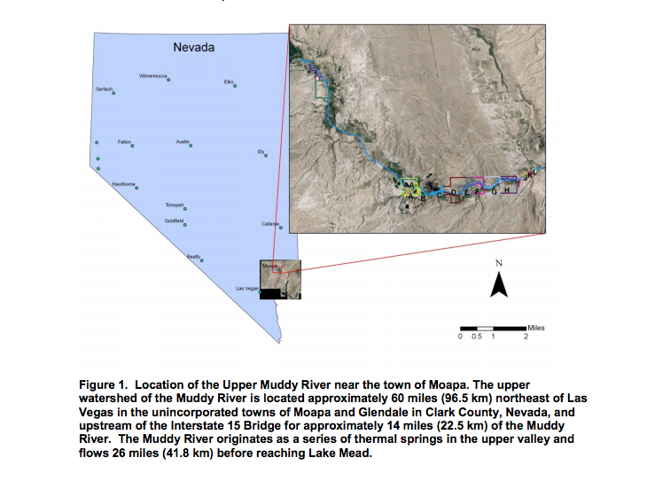
The Muddy River is about 26-32 miles long with its headwaters stemming from more than two dozen thermal springs located in the Warm Springs Natural Area about 7 miles northwest of Moapa. Its upper area provides habitat to a unique array of rare species, according to the Southern Nevada Water Authority, including two fish federally listed as endangered – the Moapa dace, or Moapa coriacea, and the Virgin River chub, or Gila seminuda. The area is habitat for other sensitive species as well, the water authority states, including three fish, two snails and two insect species.
Downstream from the Warm Springs Natural Area, the upper Muddy River flows through Clark County Desert Conservation Program’s Muddy River Reserve Unit.
Tamarisk is a non-native salt cedar with a long taproot and strong ability to survive. It is deemed problematic for a number of reasons including the salt cedar’s inflexibility, which lends to flood risks, its high and hot flammability, and its perceived effects on native habitat. Removal and restoration efforts, however, have sometimes been confounding to local, state and federal agencies.
A 2010 final report, for example, by Tanya Anderson and Louis Provencher of The Nature Conservancy to the Clark County Desert Conservation Program under Contract 2005-TNC-572-P, stated the following:
The retrospective study counter-intuitively revealed that soil salinity steadily increased for a period of 10 years after tamarisk removal. We had hypothesized that removal of the tamarisk canopy would allow successive storms to flush away accumulated salts in the soil, allow plant succession to proceed, and support increasing breeding bird abundance with time. The cover of late-successional tree species did not increase over time. Breeding bird counts decreased with time since treatment. Fish counts showed no consistent response to restoration.
In Southern Utah, a 2010 study found the southwestern willow fly catcher, a small songbird federally listed in 1995 as an endangered species, experienced higher nesting success where there was a higher percentage of tamarisk to willows, which were being planted to restore habitat, wildlife biologist Christian Edwards with the Utah Division of Wildlife Resources told St. George News. The plan at that time was to perpetuate connective habitats with willow planting over time, more slowly replacing the invasive tamarisk. In 2014, Edwards said the willow fly catcher population had been steady over the past five years.

The tamarisk’s high flammability gives cities with tamarisk adjacent to inhabited areas incentive to remove tamarisk. In 2016, an agricultural controlled burn in Washington, Utah, got out of control and reached tamarisk along the Virgin River and spread across some 10 acres along the river with flames reaching heights of 50 feet.
“When it burns, it’s super hot,” Fire Chief Dan Nelson of the Santa Clara Fire Department in Utah told St. George News in 2014. The tamarisk develop a dry, dense litter underneath them that helps to spread fire growth.
Read more: Agencies optimistic about tamarisk removal (2014) and Environmental Interests Collide Along Virgin River (2011)
Event details
- What: BLM public meeting to discuss “Muddy River Prescribed Fire Plan.”
- When: Tuesday, Dec. 13, from 7–8:30 p.m.
- Where: Marley P. Robinson Justice Court and Community Center, 1340 East Highway 168, Moapa.
Email: [email protected]
Twitter: @STGnews
just a reminder to the BLM if you accidentally burn private property you will be held as the Mestic Terrace in charge to the full extent of the law . just remember just because you are government doesn’t mean you’re right!!!
Remember the Hammons in Oregon and what happened to them .
Just a reminder to the BLM if you accidentally burn private property ‘ and you will be held liable for your actions as domestic terrorist .
Just like they did in Oregon . just remember no one likes you guys anymore and you will be held accountable .
I think it’s a great deal get rid of those ignoring trees
This is absolutely a necessary step that needs to be done for the health of the environment and the wild life that inhabits the area. It’s something that needs to be done