ST. GEORGE — The National Weather Service has issued a hazardous weather outlook for the western two-thirds of Utah and southwest Wyoming with a series of storm systems incoming around midnight Saturday bringing rain and snow showers Sunday, with winter weather increasing early in the coming week.
Saturday
Mild temperatures will continue across the outlook area Saturday with increasing clouds.
The first in a series of storm systems will bring generally light snow showers to the mountains mainly after midnight Saturday. Valleys will primarily see scattered rain or mixed rain and snow showers.
Sunday
Showers will increase again by Sunday afternoon and continue through Sunday evening as the second in a series of storm systems crosses the area.
Snow levels could reach most valley floors by late Sunday afternoon or early Sunday evening but valley accumulations are expected to be minor. However locally heavy snow will be possible in the mountains, especially west-facing slopes which may impact travel over the higher passes.
Monday following
A third and even colder storm system will impact the area Monday into Tuesday.
Periods of heavy snow will be possible along west to northwest-facing slopes and adjacent valleys and bench areas. In addition gusty northwest winds will be possible especially across northwest Utah and in the eastern valleys.
This storm is expected to have a much greater impact on travel along all routes through the mountains as well as in the western valleys.
Areas affected
The outlook area identifes the following areas: West-central Utah, southwest Utah, Utah’s Dixie, Zion National Park, Glen Canyon National Recreation Area / Lake Powell, central and southern mountains. To the north, Cache Valley / Utah portion, northern and southern Wasatch Front, Salt Lake and Tooele valleys, Great Salt Lake Desert and mountains, Wasatch mountain valleys and mountains at Interstate 80, north Wasatch mountains south of I-80, western Uinta mountains, Wasatch Plateau / Book Cliffs, western Uinta Basin, Castle Country, San Rafael Swell, Sanpete and Sevier valleys. Southwest Wyoming is also included in the outlook area.
Prepare and take caution
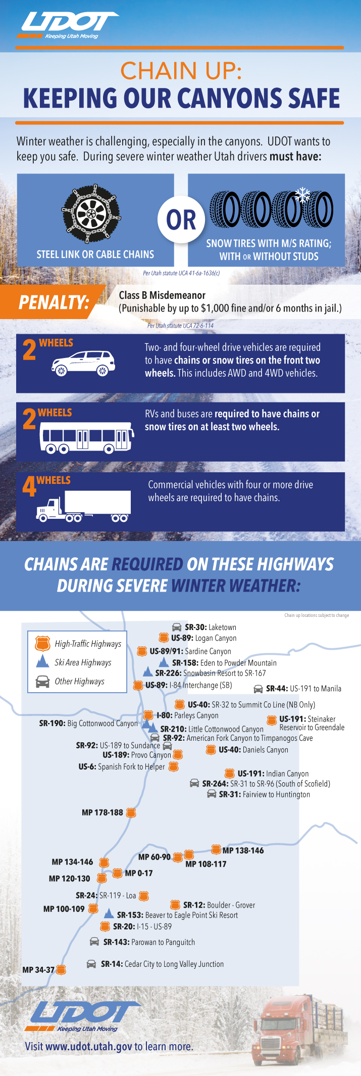
Utah law requires vehicles to have either steel link or cable chains or snow tires when driving roads in winter conditions October through March. Utah Department of Transportation’s infographic with particulars follows below.
Now is a good time to stock vehicles with a number of items that can make the difference between death and survival in the event of getting stuck in the snow. See St. George News checklist, previously published, here: Stocking your vehicle for winter; what to do in case of emergency, checklist.
Read more: What to do if you’re stuck in snow, safety kit list
Download this printable PDF: Vehicle Preparation and Safety Precautions for Winter Weather – this is a project the whole family could participate in – make it a scavenger hunt with potentially lifesaving benefits.
Resources
Email: [email protected]
Twitter: @STGnews
Just make sure your phone is fully charged in case you are involved in an accident and give yourself plenty of time to get to your destination and slow down if you need to. be safe out there and make it home to your friends and loved ones
Make sure your phone is charged that way you can still constantly pester and troll the local internet news site.
STAY HOME!