ST. GEORGE — The National Weather Service has issued a hazardous weather outlook – including gusty winds, severe thunderstorms and critical fire weather conditions – for the western two-thirds of Utah and southwest Wyoming.
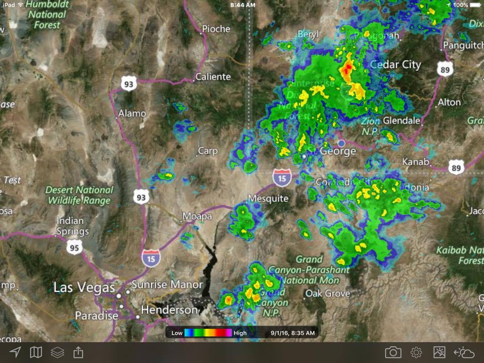
Isolated showers and thunderstorms have developed this morning over portions of southwest to west central Utah. At 7:25 a.m., the storm activity spanned from Washington to Juab counties and was moving rapidly north-northeast. Lightning and locally gusty winds are the greatest threats from these storms.
Affected areas
Cache Valley, northern Wasatch Front, Salt Lake and Tooele valleys, southern Wasatch Front, Great Salt Lake Desert and mountains, Wasatch Mountain valleys, Wasatch Mountains near Interstate 80 North, Wasatch Mountains south of I-80, western Uinta Mountains, Wasatch Plateau-Book Cliffs, Western Uinta Basin, Castle Country, San Rafael Swell, Sanpete-Sevier valleys, west-central Utah, southwest Utah, Utah’s Dixie and Zion National Park, south-central Utah, Glen Canyon Recreation Area-Lake Powell, central mountains, southern mountains and southwest Wyoming.
Day one – Thursday
Critical fire weather conditions are expected due to the combination of gusty winds, low relative humidity and thunderstorms across northern and west central Utah Thursday afternoon and evening.
Thunderstorms across the outlook area Thursday afternoon and evening will be capable of producing strong, gusty winds in addition to dangerous lightning.
Days two through seven – Friday through Wednesday
Critical fire weather conditions are again expected Friday across northern and west central Utah due to the combination of gusty winds, low relative humidity and thunderstorms.
There is a potential for strong thunderstorms again Friday across portions of central and eastern Utah. Locally, heavy rainfall cannot be ruled out near the Arizona border.
Spotter information statement
Weather spotters are encouraged to report significant weather conditions according to standard operating procedures.
Hydroplaning
Using cruise control in the rain can cause your vehicle to hydroplane. Be aware of pooling water on highways ahead of you and slow down.
Lightning
“When thunder roars, go indoors!”
What shelter you choose can make all the difference when lightning is active. The National Weather Service describes both safe and unsafe shelters:
• A safe shelter from lightning is either a substantial building or an enclosed metal vehicle.
• A safe building is one that is fully enclosed with a roof, walls and floor and utilities such as plumbing or wiring. Examples include a home, school, church, hotel, office building or shopping center. Once inside, stay away from showers, sinks, bathtubs and electronic equipment such as stoves, radios, corded telephones and computers.
• Unsafe buildings include carports, open garages, covered patios, picnic shelters, beach pavilions, golf shelters, tents of any kinds, baseball dugouts, sheds and greenhouses.
• A safe vehicle is any fully enclosed metal-topped vehicle such as a hard-topped car, minivan, bus, truck, etc. While inside a safe vehicle, do not use electronic devices such as radio communications during a thunderstorm. If you drive into a thunderstorm, slow down and use extra caution. If possible, pull off the road into a safe area. Do not leave the vehicle during a thunderstorm.
• Unsafe vehicles include golf carts, convertibles, motorcycles or any open cab vehicle.
The video found in the player at the top of this report shows storms that passed over Washington County Aug. 21 and 25.
Resources
Email: [email protected]
Twitter: @STGnews
Copyright St. George News, SaintGeorgeUtah.com LLC, 2016, all rights reserved.