ST. GEORGE – The National Weather Service out of Salt Lake City has issued an areal flood warning for parts of Kane and Washington counties for Saturday between 9 a.m. and 12 p.m.
The area primarily covers western Kane County, and southeastern Washington County, with sliver of southeastern Iron County included in the warning.
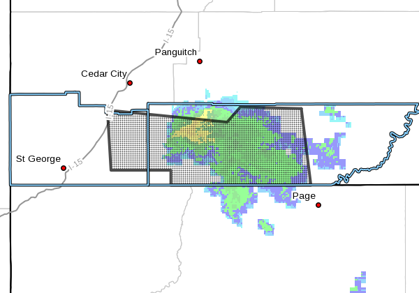
Just before 9 a.m. the NWS reported that widespread moderate to heavy rainfall is causing significant rises of normally dry washes included but not limited to pine creek in Zion National Park, and some larger river systems, including but not limited to the north fork of Virgin River in Zion National Park.
Many normally dry washes across the area will see flowing water this morning.
Elevated flows will continue through the midday hours Saturday before gradually receding by the afternoon. Many roads across the area, including Cottonwood and Wahweep, are either currently impassible or will become so shortly.
Precautionary/Preparedness Actions
Remain alert for flooding even in locations not receiving rain. Streams, rivers and normally dry washes can become raging killer currents in a matter of minutes, even from distant rainfall.
Flooding is occurring or is imminent. It is important to know where you are relative to streams, rivers or creeks which can become killers in heavy rains. Campers and hikers should avoid streams or creeks.
In short, don’t temp fate by hanging around areas prone to flash flooding.
Email: [email protected]
Twitter: @STGnews
Copyright St. George News, SaintGeorgeUtah.com LLC, 2016, all rights reserved.