ST. GEORGE – The National Weather Service has issued a winter storm watch for the St. George area and a winter storm warning for Southern Utah including Iron County as of 2:37 a.m. MST Monday.
Winter storm warning
Forecast area
Sanpete and Sevier valleys, west-central Utah, Southwest Utah including the cities of Manti, Richfield, Delta, Fillmore, Beaver, Cedar City and Milford.
Outlook
Winter storm warning is in effect until 11 p.m. this evening.
Affected area
West-central and Southwest Utah along with the Sanpete and Sevier valleys.
Snow Accumulations
Total accumulation of 10 to 18 inches across southwest Utah and along the I-15 corridor through west-central Utah, with 4 to 10 inches across the remainder of west-central Utah as well as the Sanpete and Sevier valleys.
Timing
Periods of heavy snow will continue through today before tapering off.
Winds
North to northwest winds 20 to 30 mph with higher gusts are expected today which will result in considerable blowing and drifting of snow.
Impacts
Travel will be significantly impacted along all routes through central and southern Utah through Monday. Those planning travel during this time should be prepared for hazardous winter driving conditions and plan accordingly.
Precautionary/preparedness actions
A winter storm warning for heavy snow means that significant accumulations of snow are expected or occurring. Driving conditions may be hazardous. Use caution. Keep a winter storm survival kit in your vehicle in case of an emergency.
Winter weather advisory
A winter weather advisory remains in effect until 11 p.m. this evening.
Affected area
Utah’s Dixie and Zion National Park, mainly above 3500 feet.
Snow accumulations
Storm totals above 3500 feet will be 1 to 4 inches with an inch or less in St. George
Timing
Snow will gradually taper off through early afternoon
Snow levels
Near 3500 feet
Impacts
Winter driving conditions are expected this morning including I-15 north of Leeds.
Precautionary/preparedness actions
A winter weather advisory for snow means that snow accumulations will cause primarily travel difficulties. Be prepared for snow-covered roads. Use caution.
Avalanche advisory
David Tremper of the Utah Avalanche Center has issued an avalanche advisory for the La Sal and Abajo mountains.
“I am issuing an avalanche warning this morning for the La Sal and Abajo Mountains. With the expected additional snow today and the expected increased winds tonight and on Tuesday, we will likely have a high danger of avalanches, especially in the upper elevation, wind exposed terrain.” Tremper said.
“The danger will depend on the amount of new snow, and especially, on the amount of wind. So carefully test the new snow as you travel by regularly digging down with your hand to see how well it’s bonded to the underlying snow and regularly jump on small, test slopes to see how they respond. The avalanche danger will range from MODERATE to HIGH depending on your choice of terrain,” Tremper said.
For more information, visit the Utah Avalanche Center.
UDOT road conditions
Chains are required for all vehicles on SR 20. SR-143 is closed in both directions from Brian Head to Mammoth Creek and no semis are allowed on SR-14.
UDOT emergency forecast
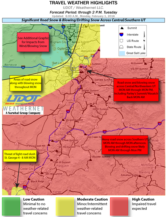
A strong winter storm will continue across most of Utah Monday morning through Tuesday morning. Heavy road snow is expected for most routes throughout Central and Southern Utah during this period.
The heaviest snow along the I-15 corridor will be between 2 a.m. Monday through 11 a.m. Monday. Light snow showers and blowing snow will begin to impact Tooele, Salt Lake, and Utah Valleys and the Wasatch Mountains Monday morning. Snow showers are expected to continue over much of the region throughout the day Monday.
Strong winds will also pick up Monday morning, creating periods of blowing and drifting snow that lasts through early Tuesday morning. Travelers should expect prolonged periods of reduced visibility and snow covered roads during this time. The following major routes will experience blowing snow and road snow through the forecast period:
- I-15, Ogden to Arizona
- I-80, Lake Point to Wyoming
- I-84, Ogden to I-80 Jct
- I-70, Entire route
- US-6, Entire route
- US-40, Entire Route
- US-89, Logan Summit; Ogden to Arizona
- US-191, Entire route
Resources
- National Weather Service
- Utah Department of Transportation road weather highlights
- Utah Avalanche Center