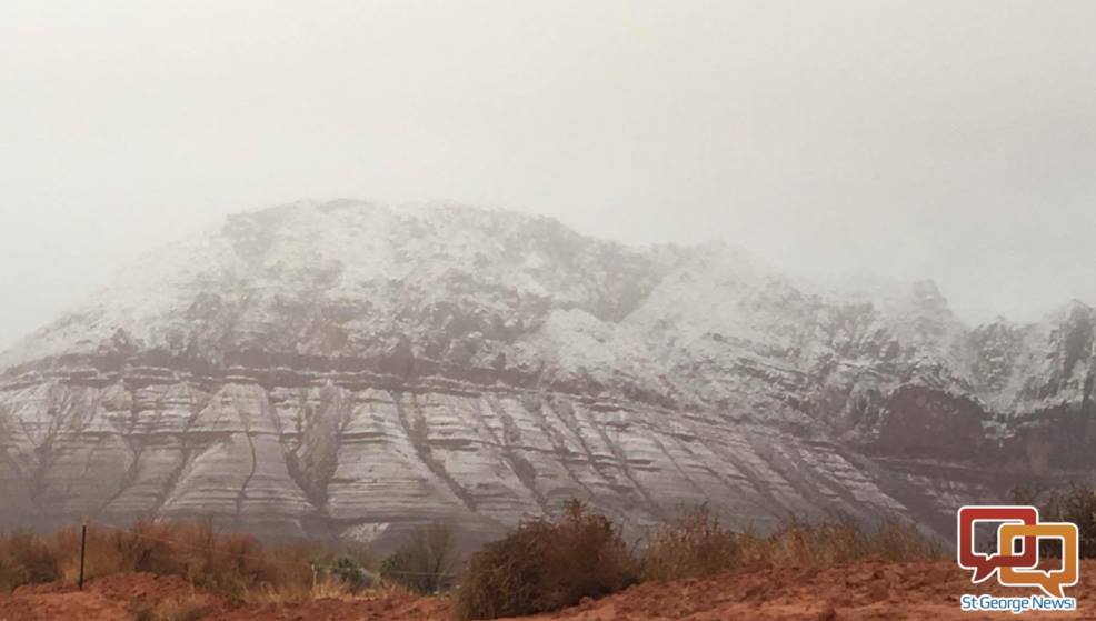
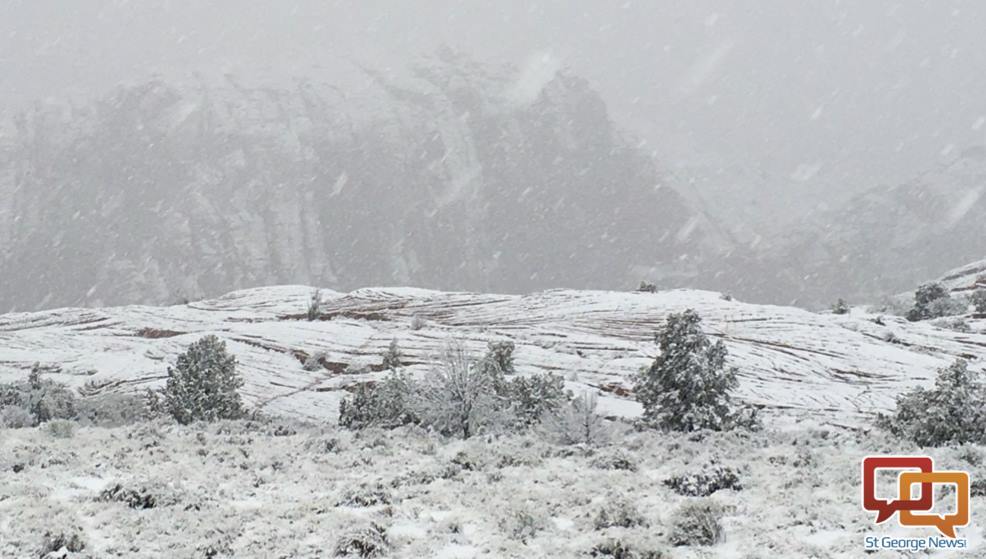
ST. GEORGE — Snow and whiteout conditions on some Washington County roads and highways Thursday morning created slick roads, slowed traffic and vehicles getting stuck or sliding, as road impacts continue. The National Weather Service has forecast snow Thursday at elevations as low as 4,000 feet and has issued a hazardous weather outlook.
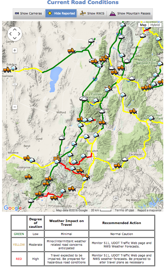
Washington County road and highway updates, as provided by Utah Department of Transportation, are indicated under each of the captioned roads highways. Snowplows are out on all the roads, Utah Department of Transportation Highway Maintenance Supervisor Todd Abbott said at 12:30 p.m., pushing everything off the road.
Road conditions, impacts
Interstate 15
Accumulating snow is creating winter driving conditions along area routes including Interstate 15, roughly from Pintura north and through the Black Ridge below the Iron County line.
By 10 a.m., I-15 traffic was getting through the Black Ridge just fine, Abbott said, but noted roads are wet. Snow could return this afternoon in which case UDOT’s snowplows will be back out on I-15.
UPDATE 12:30 p.m. – The Interstate is wet from the Arizona-Utah state line to Cedar City.
State Route 9
A bit of a storm cell moved across SR-9 this morning and UDOT has a snowplow on the highway. Abbot said motorists are able to travel the highway, though.
UPDATE 12:30 p.m. – The state highway remains wet from the I-15 interchange to Zion National Park.
State Route 18
SR-18 has presented difficult driving conditions, with snow-covered roads and near-whiteout conditions from the summit at Enterprise to about Veyo throughout the morning. Although the summit cleared some around 9:55 a.m., the snowfall continued.
“A big cell is moving through from about Winchester Hills up to about Veyo,” Abbott said at 9:55 a.m. “There is significant snowfall coming down.”
A semitractor-trailer had difficulty getting traction which caused some traffic congestion around milepost 12. In cases where trucks can’t get traction in the snow, UDOT workers manually put road salt out. Abbott said:
… what happens is we’ll have one of the plows get around the semitruck that’s stuck, put out some salt, shovel it under his tires to get him traction to get him momentum to get him going. We just have to do it manually so we can get salt under his tires to get him going.
Watch the video top of this report to see SR-18 during the 10 o’clock hour.
UPDATE 12:30 p.m. – The state highway from St. George to Veyo is wet and slushy in spots and UDOT plows are cleaning up.
State Route 59
UDOT has two snowplows on SR-59 as of the the 9 o’clock hour.
“We’ve had a big cell move through there just west of Apple Valley to the Utah-Arizona state line,” Abbott said. “Traffic is getting through there as well.
People pull off the road during snowy conditions and then get stuck in the mud the snow has created, which accounts for some incidents reported as slide-offs, Abbott said. One such case occurred at milepost 22 on SR-59 Thursday morning.
UPDATE 12:30 p.m. – The state highway from Hurricane to the Utah-Arizona state line still has patches of slush but mostly wet roads.
State Route 359
A rollover accident occurred near Pipe Spring, Arizona, on state Route 359 at milepost 20 during the 7 o’clock hour.
Read more: 1 taken to hospital following icy, too-fast crash near Pipe Spring
UDOT resources
Detailed information on specific roads and highways is available from UDOT online.
UDOT snowplow locations across the state can be seen here.
Telephone 511 for road information from UDOT.
Download the UDOT app here.
Weather outlook
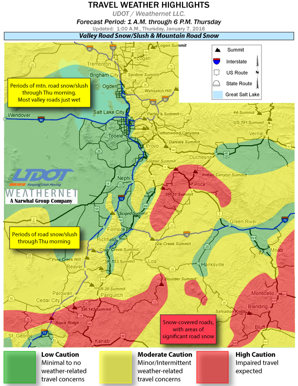
For Southern Utah, the National Weather Service predicted Wednesday that the most significant impacts Thursday would occur near the Arizona border, including Black Ridge, Brian Head, Kanab, Boulder and Monticello/Blanding.
In addition to the winter weather warning, a Hazardous Weather Outlook has been issued for the western two-thirds of Utah and southwest Wyoming in effect from Jan 7-13.
Thursday
Periods of snow will continue across portions of Southern Utah Thursday morning. Winter driving conditions can be expected on area roads above 4,000 feet.
Fog may be locally dense across Utah and southwest Wyoming Thursday.
Snow is expected to re-develop across portions of central and north-central Utah as well as southwest Wyoming later Thursday afternoon, diminishing by Friday morning. Winter driving conditions will be possible after sunset in these areas.
Friday through Wednesday
Gusty northwesterly winds may affect portions of Castle Country Friday and into Friday night.
St. George News Editor-in-Chief Joyce Kuzmanic contributed aspects of this report relating to UDOT.
Ed. note: Updated with current conditions on applicable highways at 12:30 p.m.
Email: [email protected]
Twitter: @STGnews
Copyright St. George News, SaintGeorgeUtah.com LLC, 2016, all rights reserved.