ST. GEORGE — The National Weather Service has issued a seven-day “Hazardous Weather Outlook” for the western two-thirds of Utah and southwest Wyoming, including southwest Utah, Utah’s Dixie, Zion National Park, south-central Utah, Glen Canyon Recreation Area and Lake Powell. The Utah Avalanche Center has also issued an advisory for the Moab area mountains.
Day one — Sunday
The National Weather Service forecasts a fast-moving weather system Sunday, bringing a mix of rain and snow to the valleys and snow to the mountains. Any accumulation is expected to remain minor.
Another fast-moving weather system will bring another round of valley rain-snow mix and mountain snow Sunday evening, the service predicted. Again, any accumulation is expected to remain fairly light.
Days two through seven — Monday through Saturday
The pattern is expected to remain quite active through much of the upcoming week, with moist westerly flow bringing the potential for significant snowfall and strong winds across much of the higher terrain.
Relatively warmer temperatures may support moderate rainfall in the valleys Monday, before a cold front Tuesday changes precipitation back over to snow in the valleys. Hydrologic problems resulting from rain falling on snow are possible Monday.

Avalanche advisory – Moab area
According to the Utah Avalanche Center Sunday, there is a moderate avalanche danger in wind exposed terrain on Moab-area mountain slopes steeper than 35 degrees that face northwest-east-southeast where recently deposited wind slabs have formed over the past 24 hours. There also remains a moderate but tricky avalanche danger on slopes steeper than 35 degrees that face northwest-north-east due to the presence of buried persistent weak layers in the snowpack. These areas warrant extra caution for a while, the advisory states, due to the very real potential for triggering a dangerous persistent slab avalanche.
Since about 2 p.m. Saturday, southwest winds have averaged 30 mph with gusts to near 50 mph in the affected area. Above tree line, and in exposed terrain below, the snow surface is pretty worked over, and south-facing aspects have developed a sun crust. In sheltered areas, however, conditions remain quite good with the storm of last week settled out to about 14 inches of powder. The advisory issued around 8 a.m. Sunday states it is currently 32 degrees at the Geyser Pass Trailhead and 21 inches in Gold Basin.
For more detailed information from the Utah Avalance Center, visit its website here.
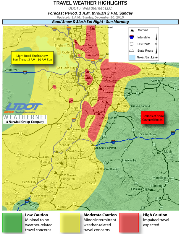
Road conditions
Utah Department of Transportation has posted road impacts expected along the I-15 corridor and routes across the central and northern mountains through 3 p.m. Sunday. Impacts on the roads during this time period will range from road slush and light snow in portions of the valleys to moderate road snow accumulations across most summit routes.
The following major roadways will be impacted by road slush and snow during the forecast period:
- I-15, ID border through Cedar City
- I-70, I-15 Jct. to Fremont Jct.
- I-80, Entire route east of Clive
- I-84, Entire route
- US-89, Entire route
- US-191, WY border to Vernal; Duchesne to Helper
- US-189, Provo Canyon
- US-6, NV border to Price
- US-40, Silver Creek to Fruitland
Detailed information on specific roads and highways is available from UDOT online.
UDOT has also posted an emergency alert for Salt Lake County in effect Sunday, advising that Big and Little Cottonwood Canyons are restricted to vehicles with chains or four-wheel drive only.
National Weather Service – spotter information statement
Weather spotters are encouraged to report significant weather conditions according to standard operating procedures.
Email: [email protected]
Twitter: @JoyceKuzmanic @STGnews
Copyright St. George News, SaintGeorgeUtah.com LLC, 2015, all rights reserved.