SOUTHERN UTAH – The National Weather Service has forecasted storm showers and thunderstorms for extreme Southern Utah developing Sunday afternoon and continuing through late night with an associated “Flash Flood Watch” in effect from noon through 6 a.m. Monday.
The next Pacific storm system along the West Coast early Sunday morning will enter the Great Basin Sunday night, preceded by developing storm showers and thunderstorms in Southern Utah early afternoon. Heavy rainfall is possible across southwest and south-central Utah by late in the day. The potential for heavy rainfall will continue through the overnight hours.
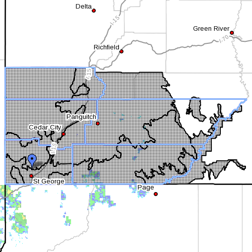
Affected areas
Southwest Utah, including Utahs Dixie and Zion National Park; south-central Utah, including Glen Canyon Recreation Area/Lake Powell; southern mountains of Utah; Bryce Canyon National Park; and Grand Staircase-Escalante National Monument. The affected areas include the cities of Beaver, Cedar City, Milford, St George, Kanab, Escalante, Bullfrong, Loa, Panguitch and Bryce Canyon.
Impacts
Normally dry washes, small streams, slot canyons, areas near recent fires and streams in steep terrain will be most prone to flooding.
Travel will become difficult on backcountry roadways due to muddy conditions.
Precautionary / Preparedness actions:
Move to higher ground now. Act quickly to protect your life.
“Get everybody. Don’t try to save personal belongings or vehicles,” Deputy Darrell Cashin, Search and Rescue Commander with the Washington County Sheriff’s Office, said to St. George News earlier this year as a watchword for those confronting a flash flood.
A flash flood can happen with little or no warning and individuals may only have seconds to act before it’s too late.
After getting to higher ground, it is important for individuals to remain where they are until either the waters have receded to a safe depth or rescue has arrived.
When you think it’s safe, wait an hour longer
“Let it recede, let it pass,” Cashin said. “When you think it’s safe, wait an hour longer.”
Turn around. Don’t drown.
Read more: Rescue commander tells how to survive a flash flood
The National Oceanic and Atmospheric Association and the National Weather Service offer safety rules for flash flooding:
- Flash flooding is a very dangerous situation
- Flash flood waves, moving at incredible speeds, can roll boulders, tear out trees, destroy buildings and bridges, and scour out new channels. Killing walls of water can reach heights of 10 to 20 feet. You will not always have warning that these deadly, sudden floods are coming. When a flash flood warning is issued for your area or the moment you first realize that a flash flood is imminent, act quickly to save yourself. You may have only seconds.
- Most flood deaths occur in automobiles – do not drive your vehicle into areas where the water covers the roadway; flood waters are usually deeper than they appear; the road bed may not be intact under the water
- Just one foot of flowing water is powerful enough to sweep vehicles off the road; if the vehicle stalls, abandon it immediately and seek higher ground; rapidly rising water may engulf the vehicle and its occupants and sweep them away
- Do not hike rivers and especially slot canyons while flash flood warnings are in place
- Do not hike alone and always tell someone where you and your buddy and others are going
- Get out of areas subject to flooding, including dips, low spots, canyons, and washes
- Avoid already flooded and high velocity flow areas. Do not try to cross a flowing stream on foot where water is above your knees
- Be especially cautious at night when it is harder to recognize flood dangers
- Do not camp or park your vehicle along streams and washes, particularly during threatening conditions
Updated 9:25 a.m. – “Flash Flood Watch” corrected to extend to 6 a.m. Monday.
Related posts
- What to do before, during, after a flash flood
- I can’t believe I survived; video of flash flood crashing down on canyoneers
- News LIVE: Fatal Hildale flood
- 7 Zion flood victims identified; Mesquite man among dead
Email: [email protected]
Twitter: @STGnews