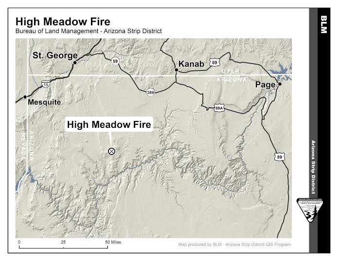
ST. GEORGE — Fire staff from the Bureau of Land Management Arizona Strip District responded to a smoke report July 15 near Mt. Trumbull and Potato Valley on the BLM Arizona Strip. The lightning-caused High Meadow Fire is located approximately 55 miles southeast of St. George. The fire is 640 acres in size and is in the Grand Canyon-Parashant National Monument portion of the BLM Arizona Strip.
The High Meadow wildfire is being managed to achieve both protection and resource objectives. These objectives include providing for firefighter and public safety, returning fire to a fire-dependent ecosystem, reducing the risk of severe fire occurrence, preserving cultural resource sites and improving wildlife habitat.
Some of the management actions taken to meet these objectives will involve multiple strategies, such as stopping undesirable fire spread on the state lands or towards private property, slowing or allowing growth depending on conditions and redirecting fire spread toward federal lands when necessary.
Recent fire activity has increased with smoke visible from surrounding areas. Ground crews and aviation are working to minimize impacts to private property (Potato Valley) to the North. With the increase in fire size and operations complexity, the fire has transitioned from an Incident Commander Type 4 to an Incident Commander Type 3.
There are four BLM roads closed to public traffic around the fire area, including BLM 1768, 1775, 1802 and 1803. While the Mohave County Road 5 remains open, the public is urged to use caution due to fire vehicle traffic, personnel and equipment activity and occasional smoke.
Resources on the fire include five wildland fire engines, one wildland fire module, two 20-person handcrews, three support water tenders and Incident Command Type 3 staff. Additional resources are ordered to support.
The Mt. Emma Fire continues to be monitored by fire staff. No smoke has been visible on the Mt. Emma Fire for the past three days.
Related posts
- Springs Fire grows despite recent rain, plays role in ecosystem
- Mason Fire in Kaibab National Forest reaches final size, 4,370 acres, 22 days
- Rains diminish High Meadow Fire on Arizona Strip
Email: [email protected]
Twitter: @STGnews
Your photo caption says Grand Canyon-Parashant National Monument is in Utah, but it is completely in Arizona.
It is, correction made. Thank you Steve.
JK
EIC