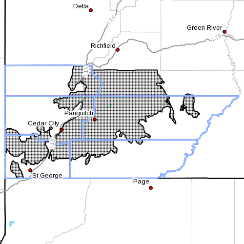
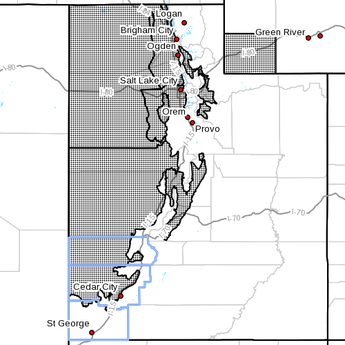
SOUTHERN UTAH — The National Weather Service in Salt Lake City has issued a “High Wind Watch” for Washington, Iron, Kane, Garfield and Beaver counties from 10 a.m. Tuesday through 10 p.m. Wednesday.
Affected areas
The eastern, southern, western and central valleys of Utah, as well as the Southern Utah mountains.
Western Uinta Basin, Castle Country, San Rafael Swell, Utah’s Dixie and Zion National Park, south central Utah and Glen Canyon Recreation Area/Lake Powell, including the cities of Duchesne, Roosevelt, Price, Castle Dale, Emery, Green River, Hanksville, St George, Kanab, Escalante and Bullfrog.
Northern Wasatch Front, Salt Lake and Tooele valleys, Great Salt Lake desert and mountains, Wasatch Mountain valleys, Sanpete/Sevier valleys, west central Utah, southwest Utah, as well as Southwest Wyoming, including the cities of Brigham City, Ogden, Bountiful, Salt Lake City, Tooele, Wendover, Snowville, Huntsville, Park City, Heber City, Manti, Richfield, Delta, Fillmore, Beaver, Cedar City, Milford and Evanston.
Southern mountains, including the cities of Loa, Panguitch and Bryce Canyon.
Winds
Eastern and southern valleys of Utah: Southwest winds may gust is excess of 60 mph from mid-morning Tuesday into the early evening hours. Winds switch to the northwest Tuesday night and may continue into Wednesday morning.
Western and central valleys of Utah: Gusty southwesterly winds are expected to develop mid-morning Tuesday – strongest across the west desert and southwest Wyoming. Winds will shift to the northwest Tuesday afternoon and strengthen. Gusts exceeding 60 mph are expected and may locally reach 70 mph across the west desert through the evening hours.
Southern Utah mountains: Very strong southwest winds may gust in excess of 70 mph beginning Tuesday. Winds will shift to the northwest Tuesday evening and remain gusty through Wednesday morning.
Impacts
Strong cross winds may affect travel for high profile vehicles. Wind sensitive operations may be impacted. Take the opportunity to secure loose items before the winds arrive Tuesday. Visibility may be reduced in areas of blowing dust. In addition, winds will cause rough chop on area lakes. Small boats will be especially prone to capsizing.
Those traveling through the southern mountains should plan for very gusty winds, especially in vicinity of Brian Head and Boulder Mountain. Wind sensitive operations may be impacted.
Precautionary and preparedness actions
A high wind watch means there is the potential for a hazardous high wind event. Sustained wind speeds of at least 50 mph or gusts of 75 mph or stronger may occur. Continue to monitor the latest forecasts.
Motorists in the advisory areas should be prepared for sudden gusty crosswinds and reduced visibility from blowing dust, which can make driving difficult.
In addition, winds will cause rough chop on area lakes. Small boats will be especially prone to capsizing.
Related posts
- What the haze? National Weather Service explains strange haze over So. Utah
- National Weather Service issues ‘Hard Freeze Watch’
- High winds flip double-wide trailer on state Route 17DSU Sustainability Club holds clean air rally
- City activates new $45,000 pollution monitor; dust issues
Email: [email protected]
Twitter: @STGnews
Copyright St. George News, SaintGeorgeUtah.com LLC, 2015, all rights reserved.