SOUTHERN UTAH – The National Weather Service has issued a “Winter Storm Watch” for Washington, Iron, Garfield and Beaver counties, with widespread heavy snow and hazardous road conditions developing late Saturday and lasting through Monday afternoon.
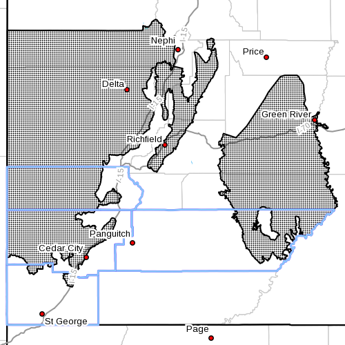
Affected area
Mountains and valleys of west central Utah, southwestern Utah and the San Rafael Swell; and the Sanpete and Sevier valleys, including the cities of Green River, Hanksville, Manti, Richfield, Delta, Fillmore, Beaver, Cedar City and Milford.
Snow accumulations
Total snow accumulations of 6-12 inches are expected across the Interstate 15 corridor in west central Utah, southwestern Utah and the San Rafael Swell, with 4-9 inches across the Sanpete and Sevier valleys and the remainder of west central Utah.
Timing
Snow showers are expected to develop late Saturday afternoon. Periods of snow, possibly heavy at times, will continue Saturday night through Monday morning. Occasional snowfall is expected to diminish by Monday afternoon.
Impacts
Winter driving conditions can be expected on area roadways, including the I-15 corridor from roughly Fillmore to north of St. George, and the Interstate 70 corridor from the junction with I-15 to the Green River area.
Travel advisories

The Utah Department of Transportation issued the following Southern Utah travel advisories for late Saturday evening through Monday afternoon.
Mountain routes will begin to have road snow by Saturday evening, with persistent snow and road impacts through Monday afternoon.
Valley routes will have a rain/snow mix beginning after 6 a.m. Sunday morning, before transitioning into mostly snow producing periods of heavy road snow by late Sunday morning and into Monday morning.
Impacted routes
- I-15, from Scipio south to Cedar City
- I-70, entire route, especially Clear Creek and Ivie summits
- U.S. 89, from Mt. Pleasant south to Kanab
- U.S. 191, from Crescent Junction south to Blanding; Indian Canyon Summit
- U.S. 6, west desert routes; Soldier Summit
Related posts
- Search and Rescue saves the day for man stranded near Kolob Reservoir
- Warm winter can wreak havoc on trees, plants, shrubs; STGnews Videocast
- Parowan residents not all happy about new snow removal ordinance
Email: [email protected]
Twitter: @STGnews
Copyright St. George News, SaintGeorgeUtah.com LLC, 2015, all rights reserved.