ST. GEORGE – The National Weather Service has issued a “Winter Weather Advisory” for much of Clark County, Nevada, extending the previous advisory to remain in effect until 4 p.m. PST Wednesday. A “Winter Weather Advisory” for snow indicates that snow will cause some travel difficulties and limited visibility.
In light of a “Winter Storm Warning” issued by the NWS for the mountains and high deserts throughout northern and eastern Arizona, the Arizona Department of Transportation issued a release Tuesday asking drivers traveling this week to be prepared. ADOT crews have been preparing for the storm and will be working 24/7 to keep roads clear, the ADOT release stated. Maintenance crews are checking the snowplows and making sure they are stocked with de-icing products. Additional snowplow drivers have been sent to areas expecting significant snowfall.
The Utah Department of Transportation has also warned that periods of light road snow and patchy ice will impact Interstate 15 between Cedar City and Cove Fort after 7 a.m. Wednesday under flurries and light snow showers. Heavier snow showers will pick up again after 6 p.m. Wednesday and impact travel with road snow through 10 a.m. Thursday.
Affected area
Most of Clark County including Mesquite, North Las Vegas, Las Vegas, Henderson, and Lake Mead National Recreation area, in Nevada.
Northern Arizona and Southern Utah as indicated in this and the linked report.
See also: Got snow? NWS upgrades alerts for So. Utah, Nevada; issues advisory for Dixie
Timing
The advisory for Nevada areas remains in effect until 4 p.m. PST Wednesday. Light snow is expected to increase over Clark County, Nevada, Wednesday morning and taper off by the afternoon.
Total Snow Accumulations
Trace amounts of snow are expected over much of the Las Vegas valley and Mesquite areas in Nevada. Some higher foothills may see up to 1 inch of snow. Areas of Clark County, Nevada, above 3,000 feet may see up to 1 inch of snow.
In northern and eastern Arizona, snow levels may be as low as 2,000 feet. Rain is expected in the lower elevations.
Wind
Winds blowing north to northeast at 15 to 20 miles per hour with gusts up to 30 miles per hour will be in effect throughout the day Wednesday in Clark County, Nevada, decreasing Wednesday afternoon.
Impacts
Clark County, Nevada: Travel could be difficult on area roads. Passes, grades, and summits will be the most treacherous areas.
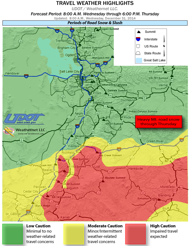
UDOT’s advisory for roads and highways in Southern Utah includes the following:
- St. George: Routes through St. George will see brief periods of slush after 9 a.m. through early afternoon Wednesday. Brief snow showers Wednesday evening will create icy patches on all roadways, it forecast.
- State Route 9 through Zion National Park: This highway will experience road slush after 3 a.m. Wednesday through Thursday morning.
- US-89 between Salina and Kanab: Periods of road snow and patchy ice will continue to impact US-89 between Salina and Kanab from 7 a.m. Wednesday through noon Thursday. Heaviest impact to travel will occur after 9 a.m. Wednesday. Patchy ice will then be a threat overnight Thursday.
- SR-153 (east of Beaver): This highway will see periods of road snow and patchy ice continuing after 7 a.m. Wednesday and lasting through Thursday afternoon.
- SR-130 through Minersville Pass: This highway will see periods of light road snow and patchy ice from 7 a.m. Wednesday through 1 p.m. Thursday.
- SR-20 (Top of Bear Valley), SR-143 over Brian Head, SR-14 near Mammoth Creek Road will see periods of heavy road snow after 7 a.m.Wednesday and lasting through Thursday afternoon.
- SR-12 over Boulder Summit, SR-24 over Wayne Summit (between Richfield and Loa), SR-72 through Hogan’s Pass will see periods of road snow, heavy at times, from 7 A.M. Wednesday through Thursday afternoon. Patchy ice will then be a threat overnight Thursday.
- SR-95 over Salvation Knoll, will see periods of road snow after 8 A.M. Wednesday through 4 P.M. Thursday. Patchy ice will then be a threat overnight.
- Spotter Information System
Weather spotters are encouraged to report significant weather conditions according to standard operating procedures.
For more information visit the National Weather Service website or for information regarding potential road travel impacts visit the Utah Department of Transportation website, and on ADOT’s “Know Snow” website at azdot.gov/KnowSnow.
Safety tips for drivers offered by ADOT
- Slow down, be patient and drive safely. Plan for extra travel time. Use extra caution around snowplows.
- Be alert: ice forms on bridges first and is hard to see.
- When driving behind a snowplow, stay back at least four car lengths. If you think you’re traveling too close to a plow, you probably are. Be safe and stay back!
- Never pass a snowplow that’s in the process of clearing snow and ice off the road.
- Maintain at least a three-quarter-full tank of gas.
- Notify someone of your travel route, destination and projected arrival time.
- Carry an emergency preparedness kit in your vehicle that includes blankets, extra clothes, a flashlight, an ice scraper, a shovel, sand for traction, a fully charged cell phone, and hazard warning lights or reflectors.
- Brake slowly to avoid any panic braking or jerking the steering wheel.
- Increase the distance between you and the traffic ahead.
- Carry plenty of food and water, and all necessary medications.
- Carry tire chains and snow cables, or use snow tires.
- Wear warm clothes to protect you during extended time periods in cold temperatures
Related posts
- Got snow? NWS upgrades alerts for So. Utah, Nevada; issues advisory for Dixie – Dec. 30
- Ring in the new year at Heart of Dixie’s 18+ New Year’s Eve party, Mesquite
- New Year’s Eve Family Bash brings in Mad Chad the chainsaw juggler
- Stocking your vehicle for winter; what to do in case of emergency, checklist
- Schnapps anyone? Red Cross busts winter-safety myths
Email: [email protected]
Twitter: @STGnews
Copyright St. George News, SaintGeorgeUtah.com LLC, 2014, all rights reserved.
That’s right, if you drive one of Nissan’s junky sports cars let this be a warning 🙂
Oh I see the accident happened only because it was a Nissan. so does that mean no fundraiser.?
Infiniti G series, junky?
You sound like someone who drives a ford.