IVINS – Directly southwest and within easy access of the desert communities of Santa Clara and Ivins lies an almost secret treasure of geological, environmental and historical wonder.
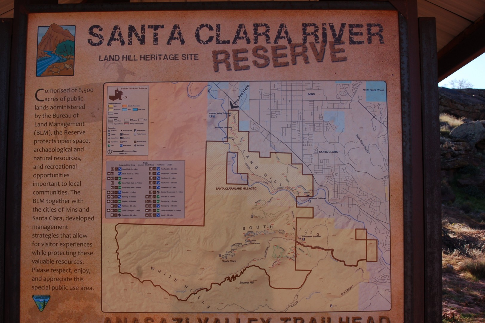
Preserved in conjunction with the two cities as well as the Bureau of Land Management’s St. George field office, the Santa Clara River Reserve is 6,500 acres of land preserved with the intention of protecting open space, archaeological sites and natural resources, as well as enabling recreational activities.
According to the BLM’s website, the Santa Clara River Reserve “encompasses the entire 1,645 acre Santa Clara/Land Hill Area of Critical Environmental Concern.” This area contains prehistoric sites and essential riparian habitat as well as habitat for the threatened and endangered dwarf bearclaw poppy and the Homgren milk-vetch.
The Santa Clara River Reserve trail system offers multiuse, nonmotorized recreation within its boundaries, including hiking, mountain biking and horseback riding.
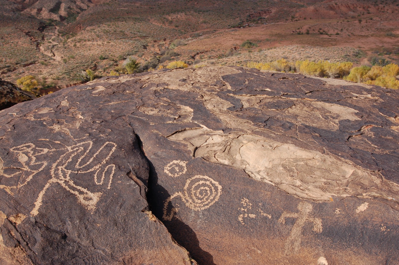
Classified as a moderate to more difficult hike, the Tempi’po’op Trail is accessed via the Anasazi Valley Trailhead and is an aggregate surfaced trail that offers visitors the opportunity to explore an ancient rock writing site as well as the remains of an Ancestral Puebloan farmstead.
Tempi’po’op, which, according to the BLM’s website, is pronounced “tumpee poo oop,” means “rock writing,” and the Tempi’po’op Trail is popular for its relatively easy access. Despite the trail’s classification as being moderate to more difficult, most day-hikers, including children, can complete the hike to the petroglyphs and access a vast collection of these ancient remnants.
The trail is open to hikers and mountain bikers (no equestrian access from this trailhead) and follows an exposed desert path that winds its way up Land Hill to the historical sites. Visitors can wander both on the ridge and just below to discover a wealth of history in an area used by both Ancestral Puebloans and Southern Paiute.
While most of the trail is wide and hard-packed surface, late summer rains have caused erosion on some sections of the trail, and caution should be exercised to avoid slipping.
The trail’s guide claims the Tempi’po’op trail provides access for wheelchair, stroller and other nonmotorized mobility devices to reach Land Hill’s cultural sites, but this would require a fair amount of maneuvering and good physical condition by the person pushing.
Because the land is protected, there are several use restrictions – some that come with hefty penalties should you break them – and visitors are expected to stay on the trail and not wander into the desert foliage and delicate environment. Visitors are additionally cautioned not to alter, erase or otherwise tamper with the cultural heritage found at the site.
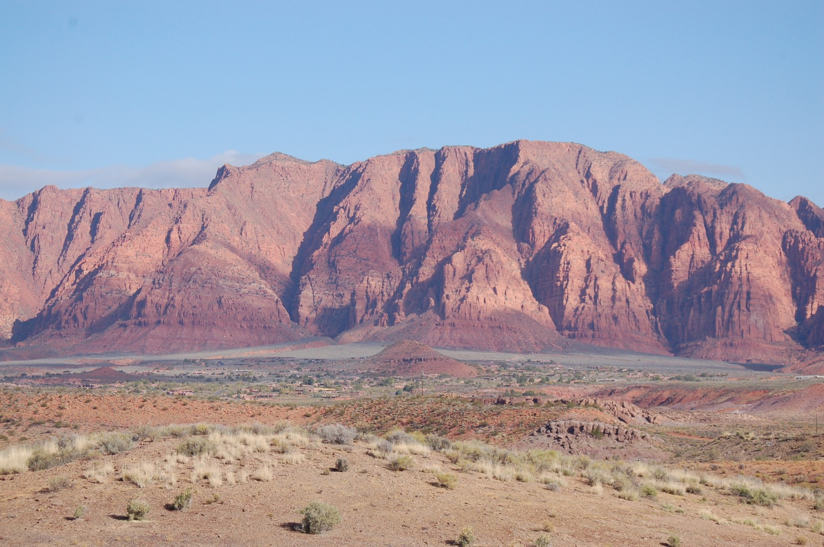
In addition to the rock writing, visitors to the Santa Clara River Reserve will be treated to 360-degree views of the area, encompassing the Red Mountain, Snow Canyon State Park, the Santa Clara River and more.
The trail is open year-round; however, because it is highly exposed (there is no shade), the best time to visit is during the late fall and early spring when temperatures are cooler. Those visiting the trail in summer should avoid hiking in the afternoon. Trail use is restricted to daylight hours.
The Tempi’po’op trail, as well as the entirety of the Santa Clara River Reserve, is a dry desert environment and is the habitat for dangerous and harmful desert animals and plants. Those seeking recreation within the reserve should wear proper clothing, bring water – even in winter –wear sunblock, and they should never go alone.
To access the Anasazi Valley Trailhead and the Tempi’po’op trail, take Exit 6 from Interstate 15 (the Bluff Street exit) and head north. Turn left on Sunset Boulevard and follow it west through Santa Clara (the road’s name changes to Santa Clara Drive). From the Jacob Hamblin historical home in Santa Clara (the road’s name changes again to Old Highway 91), continue 3.2 miles and then turn left through metal gates onto a gravel road. Travel 0.3 miles to the trailhead parking lot, where ample parking and pit toilets are available for visitors.
Click on photo to enlarge it, then use your left-right arrow keys to cycle through the gallery.

Ancient rock writing found on the Tempi'po'op trail in the Santa Clara River Reserve, Ivins, Utah, Nov. 12, 2014 | Photo by Hollie Reina, St. George News

Signs along the trail mark where visitors should and should not walk in the Santa Clara River Reserve, Ivins, Utah, Nov. 12, 2014 | Photo by Hollie Reina, St. George News

Signs along the trail mark where visitors should and should not walk in the Santa Clara River Reserve, Ivins, Utah, Nov. 12, 2014 | Photo by Hollie Reina, St. George News

Signs along the trail mark where visitors should and should not walk in the Santa Clara River Reserve, Ivins, Utah, Nov. 12, 2014 | Photo by Hollie Reina, St. George News

Views from the Tempi'po'op trail in the Santa Clara River Reserve, Ivins, Utah, Nov. 12, 2014 | Photo by Hollie Reina, St. George News

The Tempi'po'op or "Rock Writing" trail in the Santa Clara River Reserve, Ivins, Utah, Nov. 12, 2014 | Photo by Hollie Reina, St. George News

Views from the Tempi'po'op trail in the Santa Clara River Reserve, Ivins, Utah, Nov. 12, 2014 | Photo by Hollie Reina, St. George News

The Tempi'po'op or "rock writing" trail in the Santa Clara River Reserve, Ivins, Utah, Nov. 12, 2014 | Photo by Hollie Reina, St. George News

Ancient rock writing found on the Tempi'po'op trail in the Santa Clara River Reserve, Ivins, Utah, Nov. 12, 2014 | Photo by Hollie Reina, St. George News

Ancient rock writing found on the Tempi'po'op trail in the Santa Clara River Reserve, Ivins, Utah, Nov. 12, 2014 | Photo by Hollie Reina, St. George News

Ancient rock writing found on the Tempi'po'op trail in the Santa Clara River Reserve, Ivins, Utah, Nov. 12, 2014 | Photo by Hollie Reina, St. George News

Ancient rock writing found on the Tempi'po'op trail in the Santa Clara River Reserve, Ivins, Utah, Nov. 12, 2014 | Photo by Hollie Reina, St. George News

The view from Anasazi Ridge in the Santa Clara River in the Santa Clara River Reserve, Ivins, Utah, Nov. 12, 2014 | Photo by Hollie Reina, St. George News

Ancient rock writing found on the Tempi'po'op trail in the Santa Clara River Reserve, Ivins, Utah, Nov. 12, 2014 | Photo by Hollie Reina, St. George News

Gates on the south side of Old Highway 91 mark the entrance to the Santa Clara River Reserve, Ivins, Utah, Nov. 12, 2014 | Photo by Hollie Reina, St. George News

A map of the Santa Clara River Reserve is displayed at the trailhead, Ivins, Utah, Nov. 12, 2014 | Photo by Hollie Reina, St. George News

Santa Clara River Reserve use restrictions are displayed at the trailhead, Ivins, Utah, Nov. 12, 2014 | Photo by Hollie Reina, St. George News
Resources
- More information about the Santa Clara River Reserve as well as photos and maps can be found here
Related posts
- Explore: The camping cure; no homework in the great outdoors; Duck Creek
- Explore: Hauntings at Overland Hotel & Saloon in Pioche
- Explore: Seize this autumn high-country joyride before the leaves drop
- Explore: Pine Valley Mountain river walkway provides family friendly forest access
- Judge hands down decision on Anasazi Valley property
Email: [email protected]
Twitter: @STGnews
Copyright St. George News, SaintGeorgeUtah.com LLC, 2014, all rights reserved.
You should also emphasize that people need to be careful to not step on, climb on, or even touch the petroglyphs. So many times when I have come here and I see other people carelessly doing one or all three of these things.
Now see if the teenagers go destroy them.
I know that’s right! or it might be the Boy Scouts and Eagle Scouts that tag all over the art. Or some grown hipsters that think we care about what ever slack line clique they roll with. GO FALCONS!
Hee, hee, Hollie said poo! Just kidding. Interesting article. I’ve drove by but never taken the hike.
Hope these do not get trashed now like Toquerville Falls did after you guys ran that story
Grabs my can of spray and heads for the rocks