CEDAR CITY — A leafy pageant of molten reds and pumpkin-pie yellows are once again cracking through Utah’s uppermost mountain canopies. Today is the autumnal equinox, the absolute perfect time to feast your eyes upon one of Earth’s greatest gifts: a scenic joyride along the legendary Cedar Mountain traverse route — a fall leaf-lover’s cruise of a lifetime.
This scenic drive scales, descends and crisscrosses the most easily accessible high country around: Cedar Mountain — currently one of the few places in Southern Utah ripe with first-rate fall leafery. Using the mountain’s uber-scenic byways — Highways 14 and 143 — this three-hour loop (minus photo-op stops) covers 146 miles on all paved roads through some of the finest mountain towns in the south: Cedar City, Parowan and Brian Head.
So hop in your station wagon and begin in Cedar City, which as of today appears unimpressively green. Don’t worry, child; sit tight, as this tour ultimately turns mouthwatering — like marshmallows in hot cocoa on a brisk autumn night.
Within the first 20 minutes up Cedar Canyon on Highway 14, subtle tints of fiery freckles begin to hum through the deep greens; a hearty cosmic excitement stirs. Just past overlooks of Kolob’s stone fortresses, splinters of goldenrods and ruby red grapefruits start to blaze in the foreground.

At the top of the 10,000-foot mountain, the flickering fall flames detonate into a flash of nature’s foliage firework’s. Glimpse one of the route’s highlights: colorful leaves weaved in-between views of Cedar Breaks’ twisted terraces — a sight that provokes weak-kneed wonderment; a natural ecstasy that could warrant a distracted driving violation.
While circumnavigating the rest of this remote mountain, snoozy meadows and radiant reservoirs divert the eye. But, always in view, the fall symphony of leaves — a visual crescendo — Mother Earth’s rushed and reckless dress rehearsal fleeting before the sobering curtains of winter slink in.
It’s official: The high country is going off. Don’t miss the show! Check it out before it’s too late.
Simplified Directions (for Expanded Directions see below):
- Cedar City to Cedar Breaks National Monument (21.5 miles)
- Cedar Breaks to Navajo Lake (10.5 miles)
- Navajo Lake to Panguitch Lake along Highway 89 through Panguitch (63.4 miles)
- Panguitch Lake to Brian Head (18.2 miles)
- Brian Head back to Cedar City (32 miles)
Click on photo to enlarge it, then use your left-right arrow keys to cycle through the gallery.

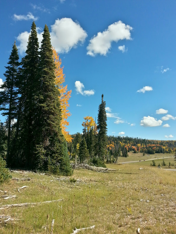
Fall colors alongside one of Utah's most scenic drives, near Navajo Lake, Highway 14, Dixie National Forest, Cedar Mountain, Utah, September 20, 2014 | Photo by Tami Thomas, St. George News

A resident heard of sheep alongside one of Utah's most scenic autumn drives, near Hancock Peak, Highway 143, Dixie National Forest, Cedar Mountain, Utah, September 20, 2014 | Photo by Tami Thomas, St. George News

An open meadow alongside one of Utah's most scenic autumn drives, near Navajo Lake, Highway 14, Dixie National Forest, Cedar Mountain, Utah, September 20, 2014 | Photo by Drew Allred, St. George News

View from an overlook atop Cedar Mountain, near Hancock Peak, Highway 143, Dixie National Forest, Utah, September 20, 2014 | Photo by Tami Thomas, St. George News
Expanded Directions:
- From Main Street in Cedar City, take Highway 14 for 18 miles east, up Cedar Canyon.
- Turn left on Highway 148. Stay on 148 for 3.5 miles for a brief side trip to the first overlook at Cedar Breaks (bathrooms with running water included). Return back the same 3.5 miles to Highway 14.
- From the Highway 14/148 intersection, turn left (east) on 14 toward the Navajo Lake overlook — a scenic beauty. Cedar Breaks to the Navajo Lake overlook is 10.5 miles, about 15 minutes. From Navajo Lake, continue on Highway 14 for 18.2 miles, slowly descending the backside of Cedar Mountain. At Highway 14’s junction with Highway 89 (at a lone gas station), turn left (north) toward the small town of Panguitch.
- From this junction, stay on Highway 89 north for 27.2 miles (about 30 mins) to Panguitch.
- In Panguitch, turn left on Panguitch Lake Road/Highway 143, which bends back west toward the top of Cedar Mountain. Stop for a look at scenic Panguitch Lake after 18 miles and about 25 minutes of driving.
- Continue west on Highway 143 for 14.2 miles to its junction with Highway 148.
- Turn right onto highway 148, which turns into 143 as you head north toward the mountain village of Brian Head for some of the most spectacular leaves to date. From the 143/148 junction, it’s 4 miles to Brian Head. If you’ve worked up an appetite, stop off for one of Utah’s classic pizza slices at Pizanos Pizzeria.
- From Brian Head, continue north (road then bends west) for 12 miles, at which point you’ll turn left onto 200 South/Highway 143.
- Drive west out of Parowan on 143 for 3 miles to the Interstate 15 on-ramp.
- From the on-ramp, travel south back to Cedar City, which is about 17 miles.
Related posts
- Explore: A fairyland of phantasmic formations, Wahweap Hoodoos
- Explore: Choride, where silver hills meet wild rock art
- Explore: Walls of petroglyphs, rainbow-colored rocks showcased at Valley of Fire
- Explore: Mtn bike Chuckwalla Trail; a backyard playground
Email: [email protected]
Twitter: @STGnews
Copyright St. George News, StGeorgeUtah.com Inc., 2014, all rights reserved.
It is really great this time of year. Will be even better in a week or so with more red leaves.
Great article! Full of the joie de autumn, my favorite season. I loved this:
But, always in view, the fall symphony of leaves — a visual crescendo — Mother Earth’s rushed and reckless dress rehearsal fleeting before the sobering curtains of winter slink in.