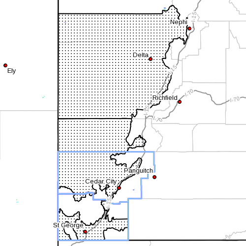
SOUTHERN UTAH – The National Weather Service has issued a “Red Flag Warning” for portions of Washington and Kane counties as well as Mesquite, Nevada, for wind and low relative humidity.
The service has also issued “Wind Advisories” for Utah’s west-central and southwest valleys, Utah’s Dixie and Zion National Park, as well as the San Rafael Swell, south-central valleys and the Glen Canyon National Recreation Area and Lake Powell.
A strong cold front is forecast to sweep across Utah Friday, working into northwest Utah in the morning strengthening as it moves south.
Strong southerly winds will develop across much of southern and eastern Utah for Friday afternoon. Winds will remain strong and gusty out of the southwest early Friday evening then switch to the northwest and gradually decrease behind the cold front in the evening.
Timing
The alert for Washington and Kane counties is in effect until 10 p.m. Friday; the alert for Mesquite is in effect from 11 a.m. to 8 p.m. Friday.
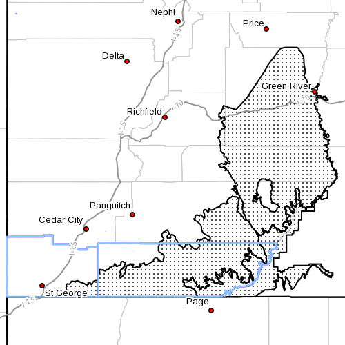
The wind advisories are in effect from noon to 10 p.m. Friday for most areas and until midnight for the San Rafael Swell, south-central valleys, Glen Canyon National Recreation Area and Lake Powell.
Affected areas
Fire Weather Zone 497 – Mojave Desert; Fire Weather Zone 498 – Grand Staircase; Fire Weather Zone 101 – Lake Mead National Recreation Area/Colorado River-Arizona side; Fire Weather Zone 102 – Northwest Deserts/Northwest Plateau; and Fire Weather Zone 466 – Lake Mead National Recreation Area/Colorado River –Nevada side.
Winds are forecast for the regions indicated including the cities of Delta, Fillmore, Beaver, Cedar City, Milford and St. George, Green River, Hanksville, Kanab, Escalante and Bullfrog.
Winds
For west-central and southwest valleys, Utah’s Dixie and Zion National Park, San Rafael Swell, south-central valleys, Glen Canyon National Recreation Area and Lake Powell, southwest winds 20-30 mph are expected with gusts near 45 mph.
For the Grand Staircase area, southwest winds 15-20 mph with gusts over 30 mph.
For Mesquite area, southwest winds 15-25 mph with gusts 35-40 mph. Winds in Mesquite will increase by late Friday morning and peak during the afternoon hours before decreasing Friday evening.
Relative humidity
For Washington County, afternoon minimum relative humidity will be down to between 3-9 percent. For Grand Staircase area, afternoon minimums will run between 3-9 percent. For Mesquite, minimum values between 4 and 8 percent.
Impacts
In Washington County and Grand Staircase, the combination of gusty winds and low relative humidity will create hazardous fire weather conditions where fuels are critically dry.
For Mesquite, the combination of gusty winds, low relative humidity and dry fuels can create conditions that are favorable for extreme fire behavior.
Strong crosswinds along with areas of blowing dust will create hazardous travel conditions Friday afternoon and evening. Boaters on Lake Powell will experience choppy conditions on open water
Precautionary, preparedness actions
A Red Flag Warning means critical fire weather conditions are either occurring now or will shortly. A combination of strong winds, relative humidity and warm temperatures can contribute to extreme fire behavior.
A wind advisory means that sustained wind speeds of at least 31 mph or gusts of 45 mph are expected. Motorists in the advisory area should be prepared for sudden gusty crosswinds which can make driving difficult.
The strong winds will create dangerous boating conditions on Lake Powell. These winds will create very choppy water which could capsize or swamp small craft.
Related posts
- Capsized kayak results in another Grand Canyon fatality
- Unplanned brush fire ignites from planned burn; fire safety tips
- Summer fire safety; prevention, awareness benefit communities
Email: [email protected]
Twitter: @STGnews
Copyright St. George News, SaintGeorgeUtah.com LLC, 2014, all rights reserved.