SOUTHERN UTAH – The National Weather Service has issued a “Winter Weather Advisory” for snow in the mountains of east-central and southern Utah in effect from 10 a.m.-10 p.m. today.

Affected areas – The western Uninta Mountains, Wasatch Plateau, Book Cliffs, central Mountains, southern mountains, including the cities of Mirror Lake Highway, Scofield, Cove Fort, Koosharem, Fish Lake, Loa, Panguitch and Bryce Canyon.
Snow accumulations – Snow accumulations are forecast at 2-4 inches.
Timing – Snow will develop klate morning Monday and continue through the afternoon before ending during the evening.
Road and hihgway impacts – Because high elevation roadways are much colder this morning, this next round of light snowfall will likely lead to snow covered roads impacting travel.
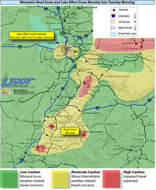
Higher impact is possible near the state Route-143 summit, state Route-153 summit, Boulder summit, state Route-31 summit, and in the Uinta mountains.
For southern Utah, Utah Department of Transportation road weather alert indicates that Interstate 15 between Parowan and Cedar City will run wet under any rain/snow showers between 9 a.m. and 5 p.m. Monday.
Precautionary/preparedness actions
A winter weather advisory means that snow accumulations will, primarily, cause travel difficulties. Be prepared for snow-covered roads. Use caution while driving.
For winter road conditions from the Utah Department of Transportation:
- Visit UDOT’s Road Weather Alerts
- Visit UDOT’s Current Road Conditions
- Obtain UDOT’s smartphone travel app.
Email: [email protected]
Twitter: @STGnews
