SOUTHERN UTAH – The National Weather Service out of Salt Lake City has issued a wind advisory for Iron, Kane and Washington counties from 9 a.m. to 7 p.m., Monday.
Affected area: The valleys of western Utah, the Sanpete and Sevier valleys, Utah’s Dixie, south-central Utah, the San Rafael Swell region and the Glen Canyon Recreation Area/Lake Powell.
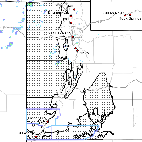
Winds: From the south at 25 to 35 mph with gusts in excess of 50 mph possible.
Timing: Winds will increase from the south Monday morning and peak by early afternoon.
Impacts: Strong winds will create travel difficulties along east-west oriented roadways including portions of I-80 and I-70. Blowing dust may reduce visibility at times.
In addition, winds will cause rough chop on area lakes. Small boats will be especially prone to capsizing.
Precautionary/preparedness actions: A wind advisory means that sustained wind speeds of at least 31 mph or gusts of 45 mph are expected. Motorists in the advisory area should be prepared for sudden gusty crosswinds which can make driving difficult.
For information on potential travel impacts, visit the Utah Department of Transportation’s website.
New from St. George News:
St. George News App for Android®
St. George News App for iPhone®
Email: [email protected]
Twitter: @STGnews
Copyright St. George News, SaintGeorgeUtah.com LLC, 2013, all rights reserved.